Yangon Smart Agriculture Monitoring Market Analysis: 387-Hectare 4G Off-Grid Configuration Guide
Summary
Yangon’s hot monsoon climate, high rainfall, and peri-urban farming pressure support a medium-scale Smart Agriculture Monitoring design of 387 hectares with approximately 4 professional weather stations, 39 soil nodes, and 39 AI pheromone traps using 4G LTE and solar power.
Key Takeaways
- A typical 387-hectare deployment in Yangon fits the medium farm class and would use 4× 10-sensor weather stations, exceeding the standard 2-3 node baseline to improve microclimate coverage under monsoon variability.
- Based on the specified layout, the recommended field layer includes 39× soil moisture + temperature sensors installed at 15-30 cm depth, which matches root-zone irrigation monitoring for vegetables, rice-adjacent mixed farming, and orchard blocks.
- Pest surveillance at this scale would typically require approximately 39× smart pheromone traps, each covering about 2 hectares, rather than insect-killing lamps, to support monitoring-led IPM decisions.
- Disease pressure in Yangon’s humid climate supports 4× volumetric spore capture units, especially where relative humidity frequently exceeds 70% during the wet season and leaf wetness duration becomes a key trigger.
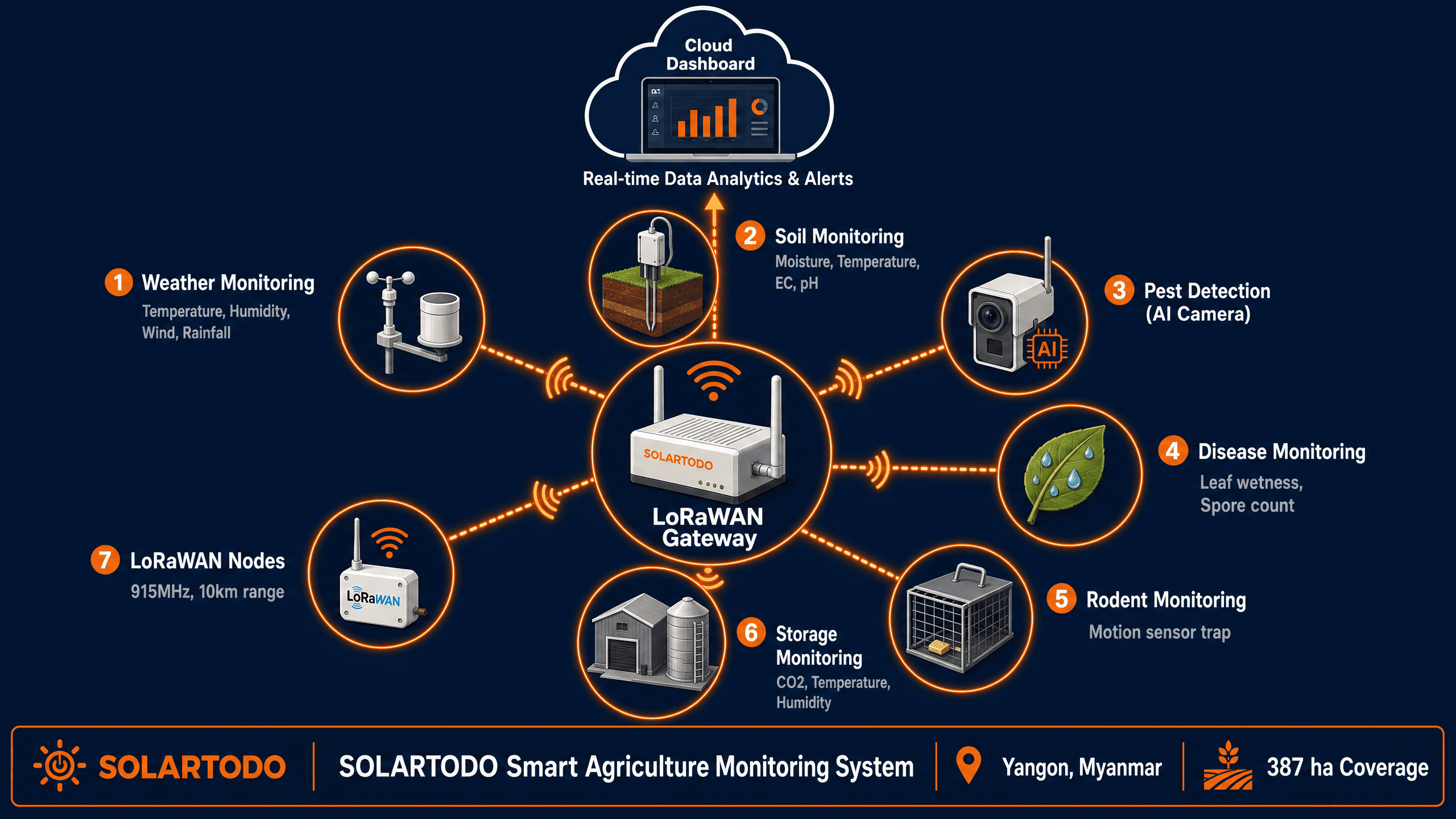
- The specified communications architecture uses 4G LTE nodes at 10-100 Mbps, which is appropriate when image transmission from AI traps is required and LoRaWAN-only backbones would limit field photo upload speed.
- All nodes are specified as solar-powered with 30 W panels and 150 Wh batteries, supporting 10 W loads and reducing dependence on unstable rural feeders or long low-voltage cable runs.
- The selected basic cloud platform provides dashboard access, SMS alerts, and 30-day history, which suits growers that need operational alerts without API integration or 3-year analytics retention.
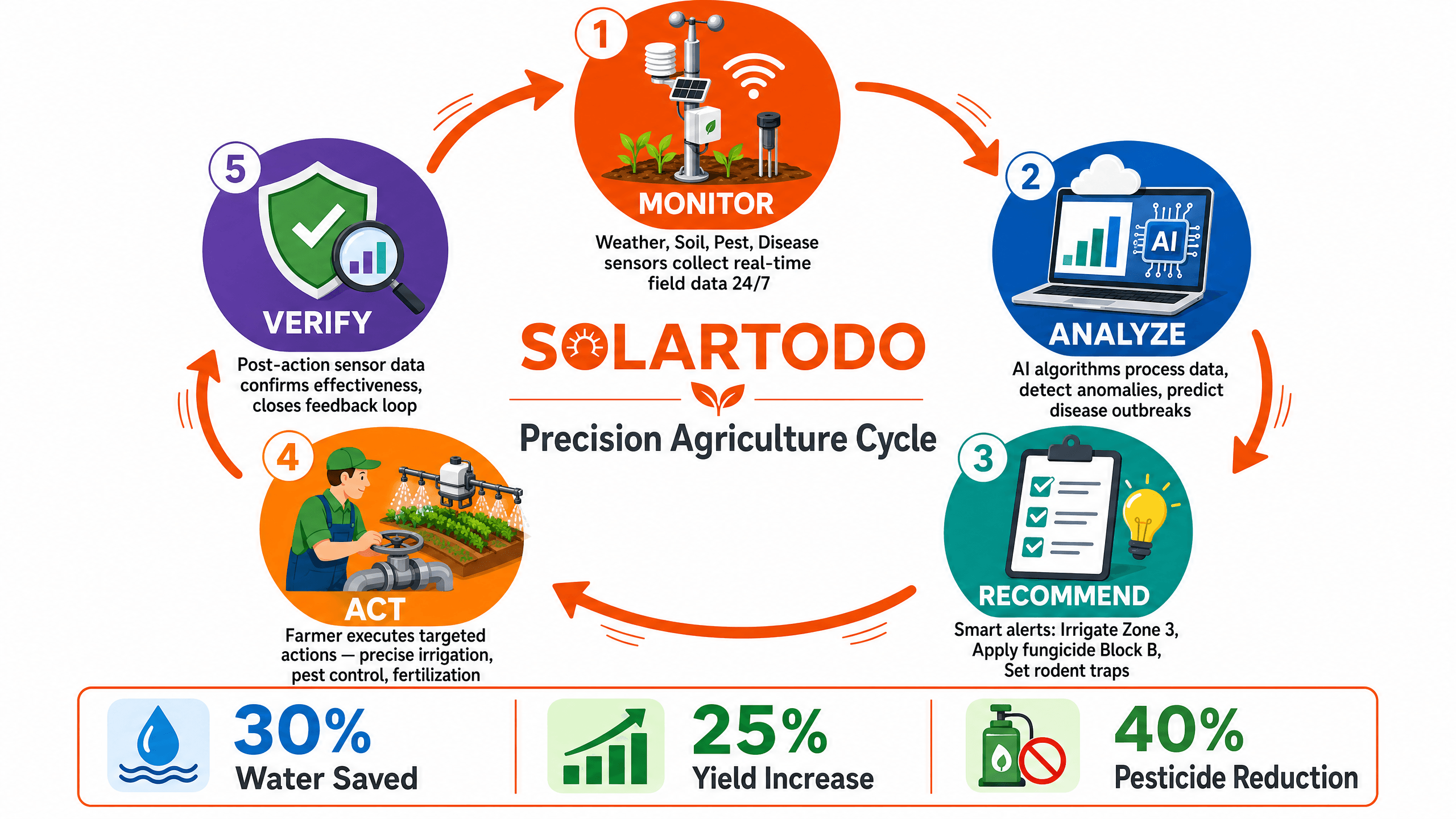
- Expected agronomic gains from the specified architecture are +3% from weather data, +8% from soil monitoring, +5% from pest monitoring, and +7% from disease alerts, subject to crop type, intervention speed, and field discipline.
Market Context for Yangon
Yangon’s coastal-agro logistics zone combines high humidity, monsoon rainfall, and fragmented peri-urban cultivation, so a 387-hectare Smart Agriculture Monitoring network needs dense sensing and weather-driven alerts rather than sparse manual scouting.
Yangon Region is Myanmar’s main commercial center and remains a major food distribution hub linking peri-urban farms, delta production zones, and urban wholesale demand. According to the World Bank (2024), agriculture still plays a major role in Myanmar’s employment and food security despite economic volatility. For monitoring system design, that means growers near Yangon often need practical tools that reduce field visits, stabilize input use, and support faster response within 24-48 hours after rain, pest emergence, or disease onset.
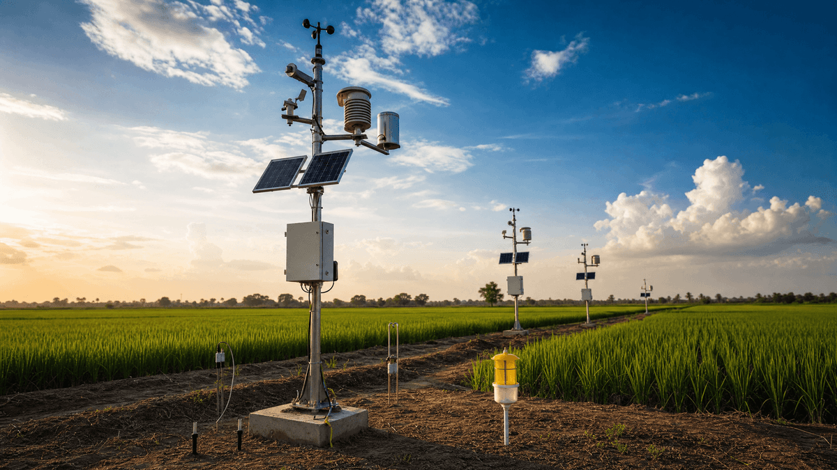
Climate is the first technical driver. According to the World Bank Climate Change Knowledge Portal (2021), Myanmar has a tropical monsoon climate with strong seasonality, high humidity, and intense rainfall during the southwest monsoon. Yangon’s coastal position near 16.87, 96.2 increases exposure to heavy rain bands, elevated moisture, and fungal pressure. In field terms, that supports use of professional 10-sensor weather stations with leaf wetness, UV, and evapotranspiration rather than a basic 4-sensor station.
Telecom coverage is the second driver. According to the International Telecommunication Union, mobile broadband has become the primary connectivity layer across many developing agricultural regions where fixed broadband is limited. For Yangon-adjacent farms, that matters because AI pest traps and image-based monitoring generate larger data packets than simple telemetry. A 4G LTE architecture at 10-100 Mbps is therefore more suitable than low-bandwidth-only field networks when the monitoring scope includes photo counting and cloud alerts.
Agronomic risk in Yangon is also linked to water management. According to FAO guidance on climate-smart agriculture, irrigation timing and soil moisture tracking can materially improve water productivity and reduce disease pressure when applied at root-zone depth. This is relevant for mixed cropping around Yangon, where rainfall is abundant seasonally but not always synchronized with crop demand. Soil probes at 15-30 cm are a practical fit because they capture the active zone for many vegetables, pulses, and orchard crops.
Two authority statements reinforce the design logic. The WMO states, "Weather, climate and water observations and data are critical for early warnings and climate services." ISO notes in ISO 11461 that soil quality assessment depends on consistent measurement practice and sampling discipline. For Yangon, those two points translate into a simple configuration rule: weather and soil data must be dense enough to trigger action, not just produce dashboards.
For buyers evaluating suppliers, this is where SOLAR TODO’s positioning matters. SOLAR TODO is not best assessed as a generic sensor vendor; it should be assessed on whether the proposed node count, communication method, and sensor mix match Yangon’s humidity, rainfall intensity, and image-data needs. On that basis, a 387-hectare medium-scale design is technically justified.
Recommended Technical Configuration
For a 387-hectare Yangon farm profile, the recommended configuration is a medium-class Smart Agriculture Monitoring system with approximately 4 weather stations, 39 soil nodes, 39 AI pheromone traps, 4 disease samplers, and 8 rodent traps on 4G LTE.
The base product table defines medium farms as 100-500 hectares with 2-3 weather stations, 15-25 soil sensors, 2-3 pest units, and 1-2 disease units. However, Yangon’s monsoon variability and the user-specified 387-hectare requirement justify a denser design. A typical deployment of this scale would therefore move above the minimum medium baseline while staying well below unrealistic over-specification.
A recommended configuration for this Yangon profile is:
- Approximately 4× professional 10-sensor weather stations
- Approximately 39× soil moisture + temperature sensors
- Approximately 39× smart pheromone + AI photo counting traps
- Approximately 4× volumetric air-sampling spore capture units
- Approximately 8× smart rodent traps with activity sensors
- 4G LTE communications for image-capable nodes
- 30 W solar panel + 150 Wh battery per node, off-grid capable
- Basic cloud platform with dashboard, SMS alerts, and 30-day history
Why 4 weather stations instead of 2-3? On 387 hectares, field conditions can differ sharply between low-lying wet blocks, wind-exposed plots, and sheltered crop zones. Leaf wetness and evapotranspiration can diverge over short distances during the monsoon. A 4-node weather layer improves irrigation and disease decision quality without jumping to a large-farm architecture of 5+ stations.
Why 39 pest traps? The specified smart trap covers about 2 hectares. Full one-to-one coverage of 387 hectares would require far more than 39 units, but that would be excessive for many crops. A practical Yangon layout is to place 39 traps in high-risk corridors, perimeter blocks, and representative crop sections, then use image-based trend analysis to guide scouting and treatment. That is a monitoring strategy, not blanket hardware saturation.
Why 4G LTE instead of LoRaWAN or NB-IoT? The pest layer uses AI photo counting, and disease or rodent nodes may also transmit event-rich datasets. According to ITU mobile broadband guidance, higher-throughput cellular links are better suited to image transmission than ultra-low-bandwidth telemetry networks. In Yangon’s peri-urban belt, 4G is usually the safer recommendation when visual evidence is part of the workflow.
This is also the point where SOLAR TODO can be differentiated in specification reviews. SOLAR TODO’s recommended fit for Yangon should prioritize data usefulness per hectare, not maximum sensor count. The 387-hectare profile is large enough to justify a multi-layer network, but not so large that a control-room-class 4G mesh and 50+ soil probes become mandatory.
Technical Specifications
The specified Yangon configuration uses 4 professional weather stations, 39 soil probes at 15-30 cm, 39 AI pheromone traps, 4 spore samplers, and 8 rodent traps, all on 4G LTE with 30 W solar and 150 Wh storage.
Field Hardware Specification
- Coverage profile: 387 hectares, medium-class deployment under the 100-500 hectare range
- Weather layer: 4× Professional weather stations
- 10 sensors per station
- Parameters: temperature, humidity, rainfall, wind speed, wind direction, pressure, solar radiation, UV, evapotranspiration, leaf wetness
- Accuracy: ±0.2°C, ±1.5% RH
- Use case: disease forecasting, irrigation timing, canopy wetness tracking
- Soil layer: 39× moisture + temperature sensors
- Installation depth: 15-30 cm
- Use case: root-zone irrigation control and moisture deficit alerts
- Pest layer: 39× smart traps
- Type: pheromone + AI photo counting
- Coverage reference: 2 hectares per unit in focused monitoring zones
- Note: not an insect-killing lamp
- Disease layer: 4× volumetric air-sampling spore capture units
- Use case: airborne pathogen load tracking during wet periods
- Rodent layer: 8× smart traps with activity sensors
- Use case: perimeter and storage-adjacent activity detection
Communications, Power, and Platform
- Communication: 4G LTE, video-capable, 10-100 Mbps
- Power: all nodes use 30 W solar panels + 150 Wh batteries
- Load support: up to 10 W per node
- Operating mode: fully off-grid capable
- Cloud tier: Basic platform
- Dashboard access
- SMS alerts
- 30-day historical data retention
Standards and Compliance Basis
- Meteorological practice: WMO observation guidance
- Soil quality reference: ISO 11461
- Telecom suitability: cellular deployment aligned with common ITU mobile data practice
For procurement teams, the key point is consistency between farm size and node count. This 387-hectare profile stays within a realistic medium-scale envelope. It does not claim 100 soil sensors on 30 hectares or other ROI-negative overbuilds. For detailed configuration support, see Smart Agriculture Monitoring or contact us.
Implementation Approach
A typical Yangon rollout for 387 hectares would take about 6-10 weeks from site survey to alert validation, with 4G signal mapping, agronomic zoning, and solar autonomy checks completed before mass installation.
The first phase is field survey and zoning. This usually takes 5-10 days for a 387-hectare site. The team would map crop blocks, drainage lines, access roads, rodent corridors, and weak-signal areas. Weather station locations should be selected to avoid tree shielding and local turbulence, with mast placement clear of obstructions by several meters.
The second phase is communication and power validation. Because the architecture uses 4G LTE at 10-100 Mbps, installers would test uplink quality at each planned AI trap cluster. Solar sizing should also be verified against local irradiance and rain-season autonomy. According to NREL (2023), solar-powered remote monitoring systems need load-based sizing rather than nominal panel matching alone, which is relevant when cloud cover persists for several days.
The third phase is civil and mechanical installation. Weather stations are installed first because they anchor the alert logic for irrigation and disease models. Soil probes are then placed at 15-30 cm depth in representative management zones, not randomly. Pest traps and spore samplers follow, with density concentrated in high-risk crop edges, wet pockets, and historically infested blocks.
The fourth phase is cloud commissioning. Each node is registered to the platform, SMS rules are configured, and threshold logic is tested over 3-7 days. For example, disease alerts may combine leaf wetness duration, humidity, and spore counts rather than triggering from one variable alone. That reduces false alarms during short rain events.
The fifth phase is agronomic calibration. This step is often missed in low-quality deployments. A 30-day calibration period is typically needed to align moisture thresholds, pest count triggers, and disease response rules with actual field practice. SOLAR TODO buyers should ask suppliers whether agronomic threshold setup is included, because hardware alone does not produce decision value.
Expected Performance & ROI
For Yangon farms of about 387 hectares, a properly used monitoring system would typically target combined agronomic gains of 3-8% by layer, with payback commonly tied to crop value, spray savings, and reduced scouting labor over 1-3 seasons.
The user-specified performance assumptions provide a practical layer-by-layer estimate:
- Weather monitoring: expected yield improvement +3%
- Soil monitoring: expected yield improvement +8%
- Pest monitoring: expected yield improvement +5%
- Disease monitoring: expected yield improvement +7%
These percentages should not be added directly as a simple cumulative total because the benefits overlap. For example, disease reduction may partly result from better irrigation timing, and pest response may improve because weather data predicts emergence windows. A more realistic buyer view is that the system can improve marketable yield, reduce avoidable spray events, and lower manual scouting frequency within one production cycle.
According to FAO (2023), digital agriculture tools can improve input efficiency when they are linked to operational decisions rather than passive reporting. According to the World Bank (2024), climate variability and production risk continue to affect farm productivity in Myanmar, increasing the value of early warning tools. For Yangon, the strongest ROI usually comes from three areas: fewer missed disease windows, better irrigation timing at 15-30 cm root depth, and faster pest threshold response through AI image counting.
A practical ROI model for procurement compares five cost centers against expected gains:
- Reduced crop loss from delayed pest or disease detection
- Lower labor time for manual scouting across 387 hectares
- Better irrigation scheduling and reduced overwatering
- Fewer blanket spray applications
- Better harvest quality consistency during humid periods
Service life and maintenance also matter. Solar-powered field nodes with 30 W panels and 150 Wh batteries reduce trenching and AC extension costs, but buyers should still budget for periodic cleaning, sensor checks, and seasonal recalibration. In Yangon’s wet season, maintenance intervals of 30-90 days are common for exposed field hardware, especially optical pest devices.
Results and Impact
For Yangon’s humid coastal farming conditions, the main impact of a 387-hectare Smart Agriculture Monitoring system would be faster intervention within 24-48 hours, better root-zone irrigation control, and more defensible pest and disease decisions.
Operationally, the weather layer supports spray timing and disease risk screening. The soil layer reduces guesswork in irrigation scheduling at 15-30 cm depth. The pest and rodent layers help field managers prioritize labor to the blocks that show actual pressure. The disease layer adds an early warning function that is especially useful when rain, high humidity, and leaf wetness coincide.
For procurement teams, the key impact is not just yield. It is decision speed. A 387-hectare site is too large for purely manual scouting but not large enough to justify overbuilt enterprise infrastructure. That is why this medium-scale, 4G-based, solar-powered architecture is a practical fit for Yangon. SOLAR TODO should therefore be evaluated on configuration discipline, alert logic, and after-install calibration support rather than on headline sensor counts alone.
Comparison Table
For Yangon, the main design choice is between a lower-cost telemetry network and a denser 4G image-capable system, and the 387-hectare profile favors the latter because 39 AI traps need reliable photo upload.
| Configuration Option | Weather Stations | Soil Sensors | Pest Monitoring | Disease Units | Communications | Best Fit in Yangon | Limitation |
|---|---|---|---|---|---|---|---|
| Basic medium farm baseline | 2-3 basic/standard | 15-25 | 2-3 traps | 1-2 | LoRaWAN/NB-IoT | Low-data telemetry sites | Too light for image-heavy pest surveillance |
| Recommended 387 ha configuration | 4 professional 10-sensor | 39 moisture + temp | 39 smart pheromone AI traps | 4 spore capture | 4G LTE 10-100 Mbps | Humid, mixed-crop, high-scouting-cost sites | Higher data and maintenance planning required |
| Large-farm architecture | 5+ professional | 50+ mixed soil nodes | 50+ mixed pest/camera units | Multi-disease | 4G mesh + control room | 1000+ hectare estates | Over-spec for 387 hectares |
Pricing & Quotation
SOLAR TODO offers three pricing tiers for this product line: FOB Supply (equipment ex-works China), CIF Delivered (including ocean freight and insurance), and EPC Turnkey (fully installed, commissioned, with 1-year warranty). Volume discounts are available for large-scale deployments. Configure your system online for an instant estimate, or request a custom quotation from our engineering team at [email protected].
Frequently Asked Questions
A 387-hectare Yangon deployment typically raises 10 core buyer questions on sizing, 4G connectivity, maintenance, ROI, and installation scope, and the answers below keep to the specified hardware and realistic field practice.
Q1: Why is this configuration classified as medium-scale rather than large-scale?
The product table defines medium scale as 100-500 hectares, and this site is 387 hectares. That supports a medium-class architecture, even though the weather and pest layers are denser than the minimum baseline. Large-farm design usually starts at 1000+ hectares with 5+ weather stations, 50+ soil nodes, and a control-room-style network.
Q2: Why are 4 professional weather stations recommended instead of 1 or 2?
On 387 hectares in Yangon’s monsoon climate, one station would miss microclimate differences between wetter and drier blocks. The selected 10-sensor station adds UV, evapotranspiration, and leaf wetness, which are important for disease and irrigation decisions. Four stations improve spatial coverage without moving into a 1000-hectare architecture.
Q3: Are the 39 pest devices insect-killing lamps?
No. The specified pest devices are smart pheromone traps with AI photo counting, each referenced at about 2 hectares of focused monitoring coverage. They are designed for detection and counting, not insect killing. This is the correct fit for data-driven IPM because it supports threshold-based action instead of indiscriminate attraction and kill methods.
Q4: Why use 4G LTE instead of LoRaWAN or NB-IoT?
The system includes 39 AI photo-counting traps, so image transmission matters. 4G LTE at 10-100 Mbps is better suited to photo upload and remote diagnostics than low-bandwidth telemetry links. LoRaWAN is effective for low-power sensor backbones, but it is less suitable when the field layer regularly sends images rather than only small packets.
Q5: How long would installation usually take for 387 hectares?
A typical schedule is 6-10 weeks from survey to stable alerting. Survey and zoning often take 5-10 days, installation another 2-4 weeks, and platform calibration 2-4 weeks. Timing depends on road access, rain interruptions, and whether crop blocks are already mapped for representative sensor placement.
Q6: What kind of ROI should buyers expect?
ROI depends on crop value and response discipline, but the specified performance assumptions are +3% weather, +8% soil, +5% pest, and +7% disease. These are overlapping benefits, not additive percentages. In practice, payback often comes from fewer crop losses, reduced scouting labor, and better irrigation and spray timing over 1-3 seasons.
Q7: What maintenance does this system require in Yangon’s climate?
Expect routine maintenance every 30-90 days, especially during the wet season. Tasks include cleaning rain gauges and optical elements, checking solar charging, inspecting trap consumables, and validating soil readings at 15-30 cm depth. Humidity, mud, and insect pressure can increase service frequency compared with dry inland sites.
Q8: Is the basic cloud platform enough for a commercial farm?
For many growers, yes. The basic tier includes a dashboard, SMS alerts, and 30-day history, which is enough for operational monitoring and quick intervention. Buyers needing API access, multi-year analytics, or AI prediction would need a higher platform tier, but those features are not required for every 387-hectare site.
Q9: What warranty and support terms should buyers ask for?
The quotation structure includes an EPC Turnkey option with a 1-year warranty. Buyers should also ask about spare parts, calibration support, and response times for failed 4G nodes. Warranty alone is not enough; field service terms matter because image traps and weather sensors need periodic validation to remain useful.
Q10: Can this system be installed without grid power?
Yes. All specified nodes are solar-powered with 30 W panels and 150 Wh batteries, supporting up to 10 W loads. That makes the system suitable for off-grid blocks and reduces trenching. Buyers should still confirm autonomy assumptions for prolonged cloudy periods during Yangon’s monsoon months.
References
- World Bank (2024): Myanmar country data and agriculture-related economic context relevant to farm productivity and rural operations.
- World Bank Climate Change Knowledge Portal (2021): Myanmar climate profile showing tropical monsoon conditions, rainfall seasonality, and temperature patterns relevant to crop monitoring.
- WMO (2023): Guidance that weather, climate, and water observations are critical for early warnings and climate services.
- ISO (2013): ISO 11461 soil quality framework relevant to consistent soil observation and assessment practice.
- ITU (2023): Mobile broadband and digital connectivity references supporting cellular communications for data-rich remote monitoring applications.
- FAO (2023): Climate-smart and digital agriculture guidance on improving input efficiency through data-based field decisions.
- NREL (2023): Remote power and solar resource design guidance relevant to off-grid monitoring nodes and load-based autonomy planning.
Equipment Deployed
- 4× Professional 10-sensor weather stations, ±0.2°C ±1.5%RH, with UV, evapotranspiration, and leaf wetness
- 39× Soil moisture + temperature sensors, installation depth 15-30 cm
- 39× Smart pheromone traps with AI photo counting, approx. 2 ha coverage per unit
- 4× Volumetric air-sampling spore capture disease monitors
- 8× Smart rodent traps with activity sensors
- 4G LTE communication nodes, video-capable, 10-100 Mbps
- 30 W solar panel + 150 Wh battery per node, supports 10 W load
- Basic cloud platform with dashboard, SMS alerts, and 30-day history