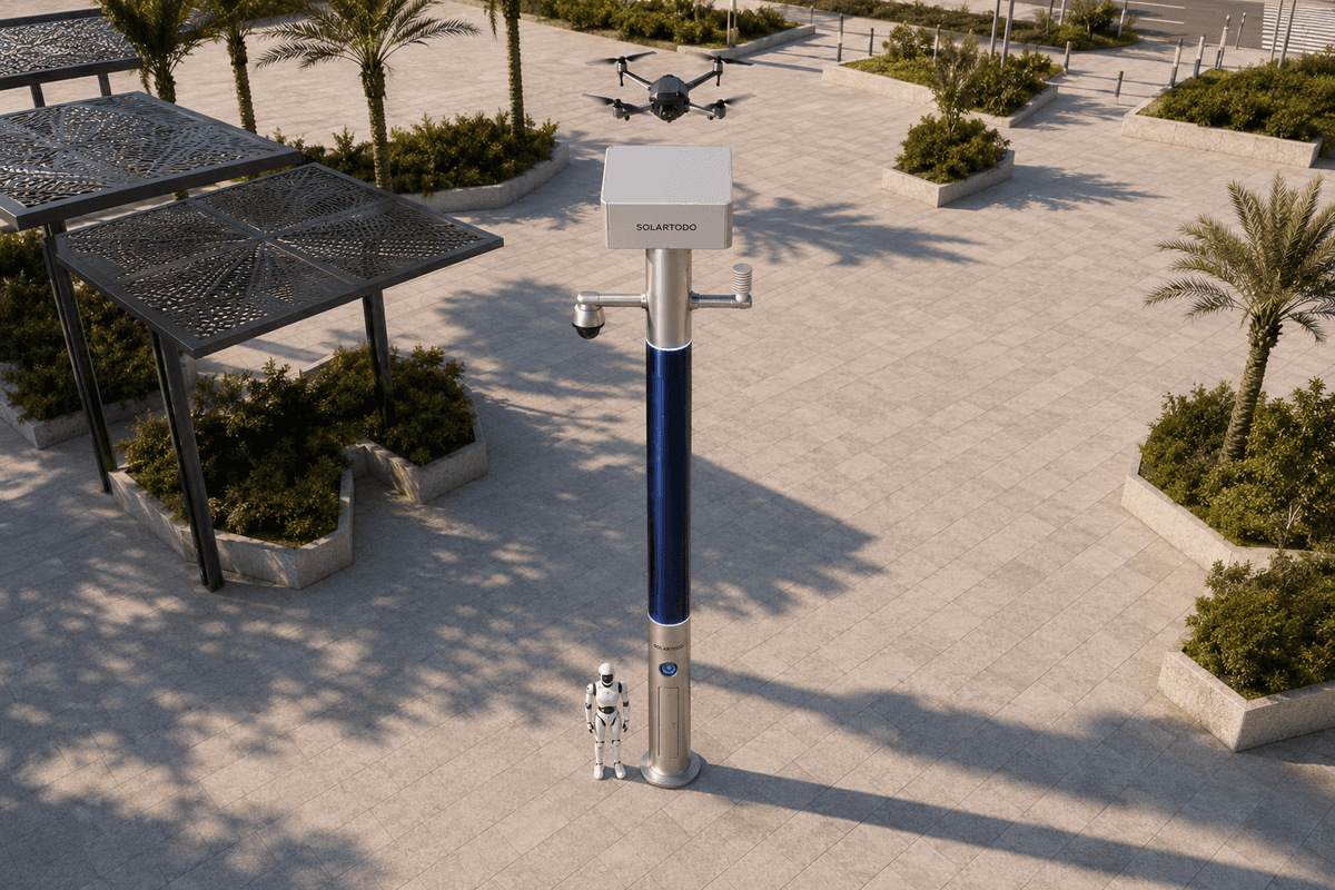
A City AI Pole is a non-lighting physical-AI urban edge node that hosts energy storage, local sensing, edge compute, drone operations, robot operations and command coordination in one off-grid pole. In this proposed Singapore deployment, SOLARTODO Sentinel Sky Hub monitors a transport campus perimeter during heatwave conditions and records de-identified evidence locally.
Singapore Deployment Context
Singapore’s transport infrastructure has a specific perimeter problem: many assets sit in compact, high-value districts where rail, depot, campus, port and road operations meet public edges, drainage corridors, elevated viaducts and service roads. The city is not mountainous in the alpine sense, but the relevant archetype for this case is mountain-like urban terrain: short steep grades, retaining walls, cut slopes, elevated decks, tree canopies, service stairs and visibility breaks around a secure campus edge. During a heatwave, these perimeter zones become harder to inspect consistently. Manual teams must check heat stress indicators, public encroachment, parked service vehicles, fallen branches, crowding near shaded edges, contractor access points and drainage areas while also preserving usable evidence for later review.
This case study frames a proposed single-pilot configuration for a transport authority evaluating SOLARTODO Sentinel Sky Hub at one campus-perimeter edge in Singapore. The task is not street illumination and not generalized city surveillance. The task is evidence collection: capture enough time-stamped, de-identified, locally processed context to support operations review, environmental response, patrol dispatch and contractor accountability without moving raw video away from the pole by default.
The pilot uses Sky Hub as a mature in-service SOLARTODO Sentinel deployment shape: a pure smart pole with no lighting system, no dependence on city power, and no site electrical tie-in. It is a fully off-grid, battery-backed micro-station with 360-degree wrapped flexible CIGS thin-film solar replenishment. The pole becomes a physical-AI node for the perimeter rather than another camera point. Its value comes from the operating loop: sensing, authorized assessment and response, edge-compute scheduling, and field operations and maintenance presented in a common-operating-picture command view.
Evidence-First Operating Model
The pain point for the transport authority is that perimeter evidence is often fragmented. A guard may see a contractor gate left open, but the weather station is somewhere else. A patrol may record crowding under a shaded slope, but the camera angle is wrong. A drone can inspect a retaining wall or perimeter fence, but a person must be available on site, batteries must be managed, and the sortie may not be tied back to the incident record. Sky Hub is configured to reduce those gaps around one defined perimeter pilot zone.
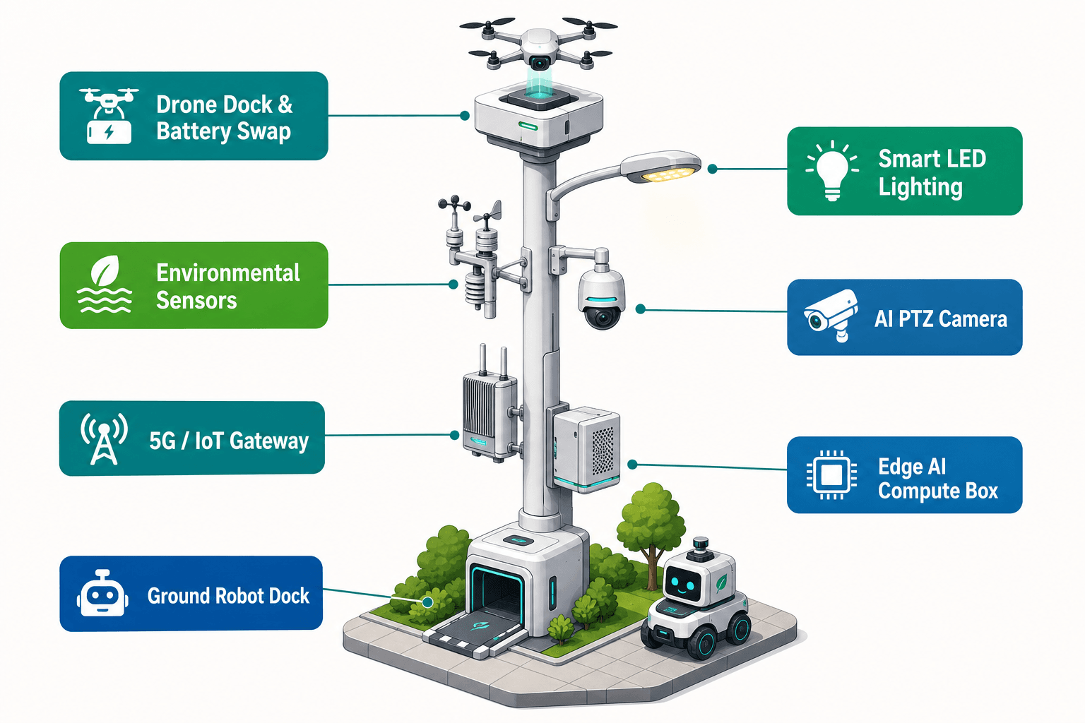
The module focus is the PTZ camera. In this deployment, the unbranded AI PTZ performs programmed patrol views over a steep campus boundary, service road, gate line, drainage channel and adjacent public-facing edge. Local perception supports anonymous vehicle count, crowd density, intrusion and perimeter awareness. It does not claim face recognition or licence-plate recognition as an active capability. When an anomaly is detected, the edge module classifies the event and stores the relevant evidence package on the pole: time, camera pose, object category, environmental readings, power state, action history and a de-identified event summary.
Heatwave operations make the environmental layer important. The nine-in-one environmental set records wind speed, wind direction, temperature, humidity, atmospheric pressure, noise, PM10, PM2.5 and illuminance. These readings help explain why the perimeter condition matters: heat stress near a queueing edge, poor air quality at a service gate, high noise near temporary works, or low wind conditions that increase thermal risk. The PTZ is therefore not only recording that something happened; it is linking visual evidence with environmental context.
Only de-identified event and status metadata may leave the pole by default. Raw video and sensor data stay on the pole for local processing and governed retrieval. The data posture is PDPL/LGPD-oriented and designed for local processing, with Singapore PDPA review expected as part of the buyer’s own deployment governance. This is not represented as certified compliance.
Air-Ground Response Loop
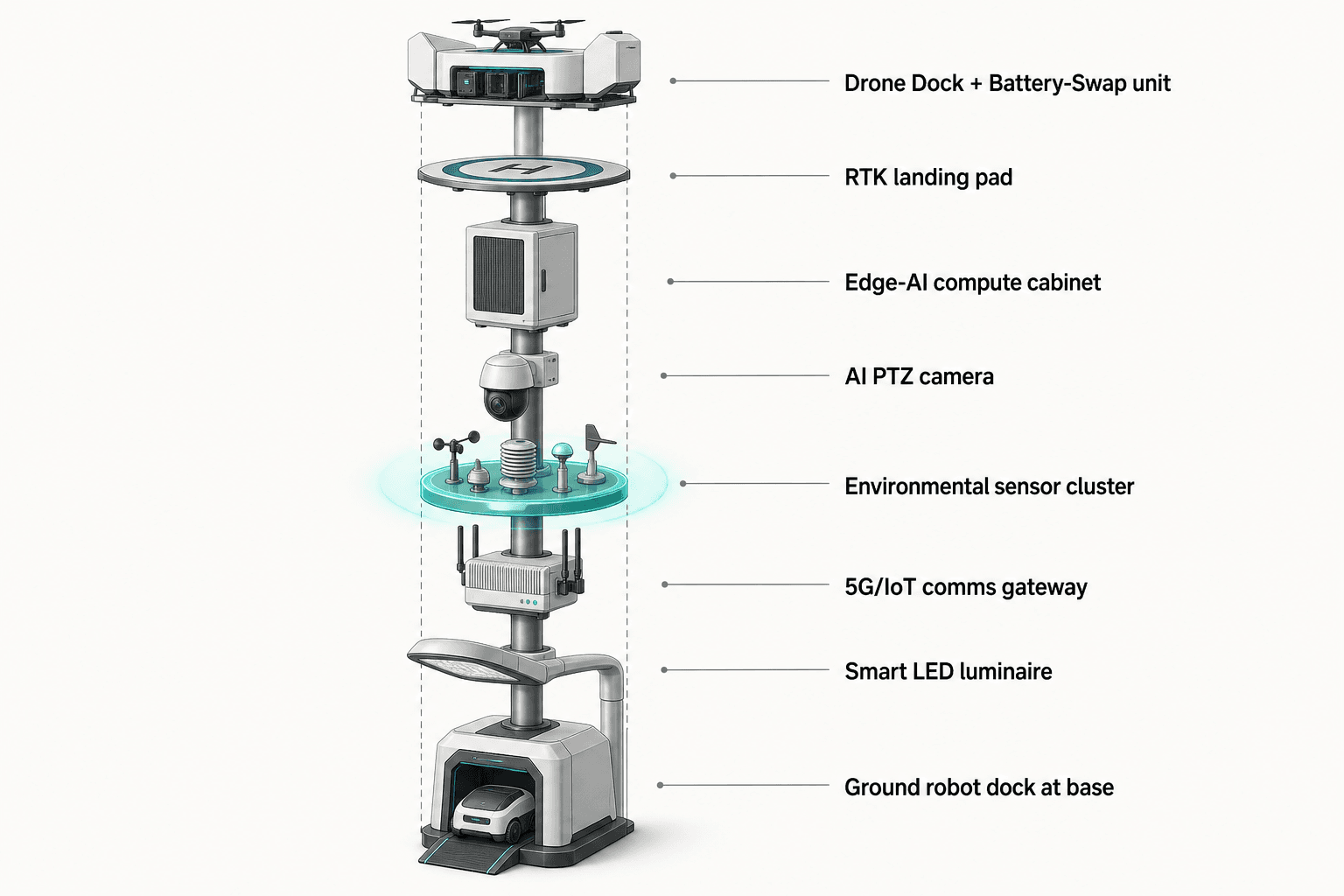
The operational loop follows the Chinese concept of sensing, inspection, response planning and coordination as one workflow. In the Singapore campus-perimeter scenario, the PTZ camera or environmental sensors first identify a condition: unusual movement at a gate, crowd density building near a shaded access path, a contractor vehicle stopped at a restricted service lane, or high heat and particulate readings near a work zone. OTATODO schedules the local workload on the pole, scores the event, and presents it in the common-operating-picture command view.
If the operator authorizes an inspection, Sky Hub can command the node’s own friendly drone to launch, fly a regional patrol route, inspect a slope or fence line, return to the pole and continue with redeployment after an automated rear-service battery exchange. The battery magazine performs a multi-bay hot-swap so a landed drone receives a charged pack and relaunches without an operator physically present at the pole. No drone brand or model is assumed; the configuration is vendor-neutral and subject to final engineering confirmation of airspace, site rules and operating procedures.
Ground robot operations add a second evidence path. A humanoid or service robot can be dispatched for autonomous patrol, alarm response, close inspection and air-ground coordination, then return to the pole base for wireless charging. In practice, the robot is useful for verifying gate state, checking heat-related obstruction, inspecting a fence section hidden under canopy, or confirming that an incident has been resolved. The drone provides quick overhead and slope-line context; the robot provides ground-level confirmation. Both are scheduled through the edge node instead of being treated as separate tools.
Counter-UAS coordination remains bounded. If an unauthorized drone is detected and tracked through the pole’s sensing inputs or optional partner-sensor feeds, Sky Hub may command its own friendly drone for soft aerial net-capture or close-approach deterrence only under human authorization. Radar is not built into the pole; it is only an optional partner-sensor input when required. The response is non-kinetic and authority-governed, with no shoot-down, no jamming, no autonomous attack and no weaponized action.
Off-Grid Energy and Scheduling
The deployment is designed as fully off-grid. Sky Hub does not rely on grid, city or site power. The cylindrical pole body carries about 15 square meters of 360-degree wrapped flexible CIGS thin-film over a vertical approximately 8-meter, 0.6-meter-wide solar body, with about 2.4 to 2.7 kWp nameplate. The important engineering point is that a vertical cylinder does not harvest full wrap output at once. Direct sun is collected mainly on the sun-facing projection, with diffuse light and reflected light adding to the total.
For a high-irradiance reference region such as Saudi Arabia, realistic clear-sky output is roughly 0.8 to 1.1 kW DC peak, typically peaking in the mid-morning and mid-afternoon rather than at noon, and about 6 to 9 kWh per day. Singapore’s actual yield would require site-specific confirmation because monsoon cloud cover, shade from viaducts, tree canopy, building reflection and maintenance access all matter. The correct positioning is therefore not unlimited pure solar self-sufficiency. The CIGS layer is a supplemental replenishment layer for a battery-backed off-grid micro-station.
For this single-pilot, energy planning is driven by duty cycle. The pole can maintain baseline sensing, environmental monitoring, local inference, event logging and communications as the priority load. High-power tasks, such as drone sorties, battery hot-swap charging, robot charging and extended PTZ patrol windows, are buffered by 5 to 20 kWh-class storage and scheduled by OTATODO according to state of charge, heatwave operating windows, mission priority and maintenance rules. During a heatwave, the command view can prioritize environmental evidence and patrol substitution during the hottest periods, while pushing lower-priority inspection flights to energy-favorable windows.
ROI Analysis for a Single Pilot
For a transport authority, the first business question is not how many sensors are on the pole. The first question is whether one physical-AI edge node can replace repeat perimeter patrol effort while improving evidence quality. This pilot should therefore be measured against planning inputs rather than claimed achieved results: how many manual inspection rounds can be automated, how many after-hours callouts can be triaged remotely, how often evidence packages contain both PTZ context and environmental readings, and how many drone or robot checks avoid sending a person into a hot, steep or exposed perimeter segment.
The KPI framing is labor replacement, but the target is not to remove human responsibility. The target is to replace repetitive walking, climbing, waiting and first-look verification with local sensing, authorized decision support and field robotics. Humans remain responsible for authorization, escalation, legal response and maintenance. In a single-pilot evaluation, a buyer can compare planned manual patrols per week against automated PTZ patrol sweeps, drone sortie availability, robot inspection tasks and evidence package completeness.
A practical pilot scope would define one perimeter segment, one heatwave operating calendar, one command view role group, one evidence retention policy and a small number of response playbooks. Example playbooks include unauthorized access at a service gate, crowd density at a shaded boundary, environmental threshold breach at a work zone, contractor vehicle dwell near a restricted access point, and suspected unauthorized drone presence. Success should be evaluated by target patrol substitution, event review time, evidence completeness and maintainability, not by invented detection rates or national-scale rollout claims.
Subject to final engineering confirmation, the proposed configuration gives the authority a way to test whether a pure smart pole can become an off-grid perimeter operations node: PTZ-led evidence collection, local environmental context, edge inference, drone inspection, robot verification, human-authorized C-UAS coordination and de-identified metadata reporting from one managed Sky Hub point.
System Configuration
| Parameter | Configuration |
|---|---|
| Deployment mode | Single-pilot Sky Hub node for one Singapore transport campus-perimeter segment, subject to final engineering confirmation |
| Pole form | Pure non-lighting smart pole, fully off-grid with on-pole CIGS replenishment and battery-backed operation |
| Camera | Unbranded AI PTZ for 360-degree patrol views, anonymous vehicle count, crowd density, intrusion and perimeter awareness |
| Environmental monitoring | Wind speed, wind direction, temperature, humidity, atmospheric pressure, noise, PM10, PM2.5 and illuminance |
| Edge AI compute | Jetson-class on-pole inference module, Orin- or Thor-class, with raw video and sensor data processed locally |
| Energy system | ~15 m² wrapped flexible CIGS, ~2.4-2.7 kWp nameplate, 5-20 kWh-class storage, duty-cycle scheduling |
| Air-ground operations | Autonomous drone launch, return and multi-bay battery hot-swap; ground robot patrol and wireless charging at pole base |
How It Works
- On-pole PTZ or environmental sensors flag a perimeter anomaly.
- Edge AI classifies the event, scores urgency and keeps raw data local.
- The COP command view presents de-identified metadata for human assessment.
- An authorized operator dispatches a drone or ground robot when field confirmation is needed.
- OTATODO records action history, sensor context, power state and mission logs on the pole.
- De-identified event status is shared with the authority platform for review and KPI tracking.
Planning Assumptions (Indicative)
Illustrative planning inputs a buyer can recompute — target metrics, not achieved results. Subject to final engineering confirmation.
| Metric | Planning assumption | Indicative value |
|---|---|---|
| Inspection labor | PTZ patrol and event-triggered drone checks replace repeat manual perimeter walks during defined heatwave windows | ~10-20 patrol rounds per week targeted for automation |
| After-hours triage | Local event summaries allow supervisors to assess low-severity anomalies before dispatching a person on site | ~30-50% of first-look reviews handled remotely as a planning target |
| Evidence completeness | Each qualifying event should combine PTZ context, environmental readings, power state, action history and operator decision record | ~90% complete evidence packages targeted for pilot review |
| Drone redeployment | Multi-bay battery hot-swap supports consecutive authorized inspection sorties without a battery runner at the pole | ~3-5 consecutive sorties planned per charged magazine cycle |
| Robot substitution | Ground robot verifies selected gate, fence and slope-edge events before a human maintenance or security response is sent | ~5-10 ground checks per week targeted for substitution |
Deployed Equipment
- SOLARTODO Sentinel Sky Hub off-grid pole body
- 360-degree wrapped flexible CIGS thin-film solar layer
- Battery-backed energy storage and power management cabinet
- AI PTZ camera module
- Nine-in-one environmental sensor set
- Jetson-class edge AI compute module
- Autonomous drone operations bay with multi-bay battery magazine
- Ground robot wireless charging interface at pole base
Frequently Asked Questions
Is Sky Hub a smart streetlight for Singapore roads?
No. Sky Hub is a pure smart pole and physical-AI edge node with no lighting system. In this Singapore case, it is proposed for a transport campus perimeter, where the operating task is environmental evidence collection, PTZ patrol, drone inspection, robot verification and command coordination, not road or pathway illumination.
How does the pilot improve evidence collection without exporting raw video?
The PTZ camera and environmental sensors process events on the pole through edge AI. Raw video and sensor data stay local by default. The authority receives de-identified event and status metadata, such as event type, time, environmental context, camera pose, mission action and health state, with governed retrieval policies defined during deployment planning.
Can the pole run fully off-grid in Singapore’s cloudy conditions?
The system is designed as fully off-grid with battery storage plus CIGS solar replenishment, not as unlimited solar self-sufficiency. The reference energy numbers are ~2.4-2.7 kWp nameplate, roughly 0.8-1.1 kW DC clear-sky peak and 6-9 kWh/day in high-irradiance regions. Singapore yield requires final site engineering confirmation.
What makes the PTZ camera the focus of this deployment?
The PTZ is the primary evidence-collection instrument because it can patrol multiple campus-perimeter views from one elevated node and connect each event to local environmental data. It supports anonymous vehicle count, crowd density, intrusion and perimeter awareness, while avoiding claims of face recognition or licence-plate recognition as active deployed capabilities.
How are drone and robot operations governed?
Drone and robot tasks are scheduled by OTATODO and shown in the common-operating-picture command view. A drone can inspect a slope, gate or fence line and return for automated battery exchange. A ground robot can verify conditions at base level and return for wireless charging. Human authorization remains part of regulated or sensitive response.
What does counter-UAS coordination mean in this proposal?
Counter-UAS coordination means the node can detect and track an unauthorized drone using its sensing stack or optional partner-sensor inputs, then command its own friendly drone for soft net-capture or close-approach deterrence only when authorized. It does not mean shoot-down, jamming, denial, autonomous attack or any weaponized response.
Explore Further
- City AI Pole / smart streetlight product line
- More smart-city deployment cases
- Talk to our engineering team
Planning a similar physical-AI deployment for streets, campuses or public spaces? Request an engineering consultation