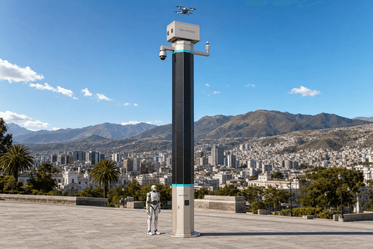
Quito high-altitude security corridors: SOLARTODO Sentinel City AI Pole 22-node edge configuration
Summary
Quito’s 2,850 m Andean altitude, 2,679,722 residents, and 34.5 kV Ecuador feeder class support a typical 22-unit SOLARTODO Sentinel City AI Pole layout at 30 m spacing for off-grid edge sensing, drone service, and robot patrol.
Key Takeaways
A 22-node Quito configuration would cover about 660 m of corridor frontage at 30 m spacing, subject to foundation, line-of-sight, and permitting checks.
- Quito sits at approximately 2,850 m elevation, so battery autonomy, wind exposure, UV aging, and access logistics matter more than coastal salt-air design.
- INEC reports Quito at 2,679,722 residents and 638 people/km2 in 2022, supporting dense but privacy-preserving edge analytics.
- ARCERNNR’s 2024 electricity dataset lists Ecuador medium-voltage feeder classes from 6.3 kV to 34.5 kV; Sentinel remains off-grid and does not require utility power.
- A typical 22-unit deployment at 30 m intervals would use 22 SOLARTODO Sentinel City AI Pole edge nodes, 22 battery systems, and 22 drone-service modules.
- Each pole uses an approximately 2.8-3.2 kWp integrated PV body as replenishment, with practical clear-sky peak output around 1.0-1.3 kW DC in high-irradiance conditions.
- Storage should be specified in the 5-20 kWh class per pole, with Quito duty cycles tuned for patrol frequency, sensor uptime, and rainy-season reserve.
- Local processing should keep raw video and sensor streams on the pole; only de-identified event and status metadata should leave the site.
Market Context for Quito
Quito’s security-edge infrastructure profile is defined by a 2,850 m inland Andean setting, dense municipal activity, and steep urban terrain rather than coastal corrosion. According to INEC (2025), Quito’s population grew from 319,221 in 1950 to 2,679,722 in the 2022 census, with a reported density of 638 people per square kilometer. That makes anonymous crowd-density, intrusion, and vehicle-count metadata more valuable than raw-video backhaul, especially around campuses, public facilities, transport interchanges, industrial perimeters, and hillside access roads.
According to UNESCO (2025), Quito is a metropolitan capital in the Andean region at about 2,850 m altitude and concentrates more than 40% of Ecuador’s public administration. UNESCO states, "2 850 metres," which is a compact but important engineering fact: high elevation increases UV exposure, changes thermal cycling, and can make access logistics slower on steep approaches. Quito’s historic center, inscribed by UNESCO in 1978, also creates a constraint that generic smart-city pole layouts miss: dense colonial streets and heritage zones require careful siting, non-invasive foundations, and visual-impact review.
Climate is also not generic Latin America. According to FAO’s Quito context profile, the main urban-interandean zone sits roughly between 2,400 m and 3,100 m, has average temperatures around 10-16 C, and receives about 960 mm of annual precipitation. The dry season from May to August supports stronger daytime replenishment, while September-April rain periods require conservative battery reserve and scheduled drone sorties rather than continuous high-power flight.
The grid and procurement context shapes risk allocation even though SOLARTODO Sentinel is fully off-grid. According to ARCERNNR/INEC metadata for Ecuador’s 2024 electric-sector statistics, medium-voltage feeders recorded in the national dataset range from 6.3 kV to 34.5 kV, with 13.8 kV representing 79.8% of listed feeder cases and 34.5 kV representing 0.3%. For a pure smart pole, this matters mainly for setback, utility coordination, and electromagnetic environment review, not for power supply.
Public-sector sales also need Ecuador-specific process discipline. According to the U.S. International Trade Administration (2024), Ecuador public contracting is regulated through LOSNCP and the SERCOP system, and suppliers typically need RUP registration for state procurement. For municipal or public-agency buyers, a SOLARTODO response should therefore package Spanish technical datasheets, local installation method statements, privacy impact notes, warranty terms, and after-sales service commitments before bid submission.
Recommended Technical Configuration
A Quito-ready Sentinel design would use 22 off-grid edge-node poles across approximately 660 m, with every quantity treated as project-based and engineering-confirmed. A typical 22-unit deployment in this profile would consist of approximately 22 SOLARTODO Sentinel City AI Pole nodes in Sky Hub pole form, installed at about 30 m spacing where sight lines, pedestrian flow, and maintenance access allow. The product fit is not lighting; it is an off-grid sensing, compute, drone-service, and robot-service node for security corridors, government campuses, industrial parks, transit perimeters, and critical-infrastructure approaches.
Recommended functional configuration:
- 22 pure smart poles with no lighting system and no dependency on grid, city, or site power.
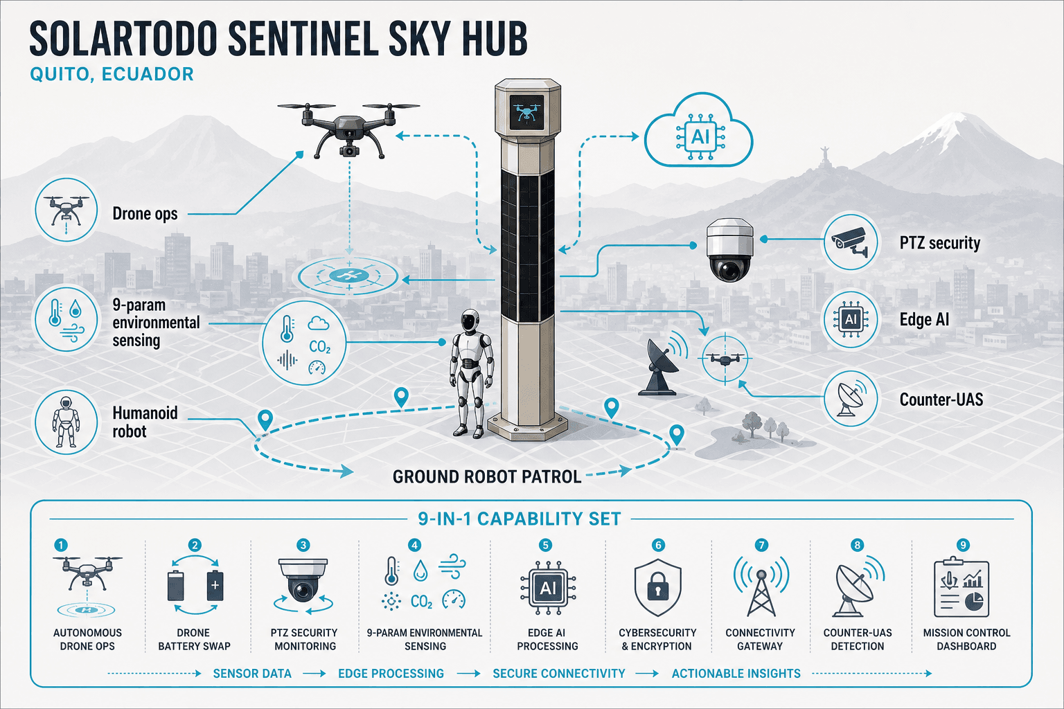
- 22 edge AI compute modules in a Jetson-class architecture for local inference, workload scheduling, and event filtering.
- 22 integrated environmental monitoring sets covering wind speed, wind direction, temperature, humidity, pressure, noise, PM10, PM2.5, and illuminance.
- 22 PTZ security-sensing packages configured for anonymous vehicle count, crowd density, intrusion, and perimeter awareness.
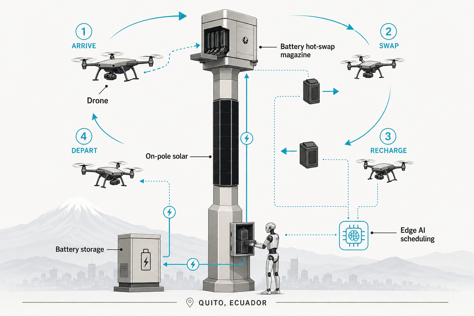
- 22 drone-service interfaces supporting launch, patrol, inspection, return, battery exchange, and mission-log management.
- Optional partner-sensor inputs for radar or other external feeds, treated as separate integrations and not pole hardware.
- Human-authorized non-lethal C-UAS coordination limited to detection, tracking, soft aerial net-capture, or close-approach deterrence.
For Quito, the operational logic should prioritize event-triggered patrol rather than continuous drone activity. A 22-node corridor can create overlapping awareness zones while keeping raw video and sensor streams processed locally on the pole. Only de-identified event metadata, system health, mission status, and maintenance alerts should be sent to the command view, aligning with Ecuador’s LGPD-oriented privacy expectations without claiming certification.
Technical Specifications
The recommended Quito configuration uses 22 off-grid Sky Hub nodes with 2.8-3.2 kWp integrated PV replenishment and 5-20 kWh storage per pole.
Core specifications for a typical Quito engineering submittal:
- Product: SOLARTODO Sentinel City AI Pole, Sky Hub pole-form physical-AI edge node.
- Quantity: approximately 22 units, subject to survey, route geometry, and final engineering confirmation.
- Spacing basis: about 30 m between nodes, equivalent to roughly 660 m of continuous corridor before setbacks and terrain corrections.
- Power architecture: fully off-grid, battery-backed micro-station with on-pole solar replenishment; no grid tie required for normal operation.
- Solar replenishment: eight integrated monocrystalline PV faces, approximately 2.8-3.2 kWp nameplate, with about 1.0-1.3 kW DC realistic clear-sky peak in high-irradiance regions.
- Daily harvest benchmark: approximately 7-10 kWh/day in high-irradiance reference conditions; Quito output should be confirmed by site-specific shading, cloud, and horizon analysis.
- Storage class: 5-20 kWh per pole, sized by drone sortie frequency, robot duty cycle, sensor uptime target, and rainy-season reserve.
- Edge compute: Jetson-class local AI module for inference, mission scheduling, sensor fusion, and event filtering.
- Data handling: raw video and sensor streams stay on the pole; only de-identified events and operational metadata leave the site.
- Security analytics: anonymous vehicle count, crowd density, intrusion, perimeter awareness, and alarm correlation.
- Environmental telemetry: wind speed, wind direction, temperature, humidity, atmospheric pressure, noise, PM10, PM2.5, and illuminance.
- Drone service: launch, patrol, inspection, return, task redeployment, mission logs, and automated battery exchange.
- Ground robot service: patrol dispatch, alarm response, inspection, air-ground coordination, and return-to-base wireless charging.
- C-UAS coordination: detection, tracking, human-authorized response, soft net-capture, or close-approach deterrence only.
According to the Global Solar Atlas/World Bank dataset metadata (2023), Ecuador solar layers include PVOUT, GHI, DNI, DIF, GTI, optimum tilt, and related raster data. The Global Solar Atlas states, "PVOUT is expressed in kWh/kWp," which is the correct unit for comparing solar replenishment potential. For Sentinel sizing, that metric informs replenishment reserve only; the pole’s service availability still depends on battery capacity and duty-cycle scheduling.
Implementation Approach
A 22-node Quito rollout would usually run through 6 controlled phases, from corridor survey to commissioning and operator handover. Phase 1 is corridor selection and utility-context screening. The engineering team should confirm GPS positions, slopes, seismic foundation assumptions, heritage restrictions, line-of-sight, emergency access, underground utilities, and nearby medium-voltage setbacks. Quito’s steep valleys and dense old-town streets make this phase more important than a flat industrial-site layout.
Phase 2 is technical submittal and procurement documentation. For public owners, the package should support SERCOP-style review with Spanish documentation, supplier registration requirements, warranty scope, acceptance tests, cybersecurity notes, and privacy architecture. According to the U.S. International Trade Administration (2024), SERCOP manages public procurement data and information under open-data principles, so traceable specifications reduce evaluation friction.
Phase 3 is logistics and CKD or modular delivery planning. Quito’s elevation and urban access constraints can affect crane choice, delivery windows, and storage locations. Road geometry near hillsides, valleys, and heritage areas should be checked before selecting vehicle length, unloading points, and temporary traffic controls.
Phase 4 is civil works and pole erection. Foundations should be engineered for local soil, slope, drainage, seismic requirements, and the final equipment mass. Pole positioning should avoid blocking pedestrian paths, preserve emergency access, and provide maintenance clearances for drone and robot service tasks.
Phase 5 is commissioning. Each node should complete battery state checks, PV replenishment tests, camera calibration for anonymous analytics, environmental sensor validation, drone service state-machine tests, robot docking tests, local event filtering, and command-view integration. Final acceptance should verify that raw video and raw sensor streams remain on-pole.
Phase 6 is operations handover. Operators should receive route planning rules, human-authorization procedures for C-UAS response, preventive maintenance schedules, event-retention policies, and escalation workflows. The operational loop should follow sensing, authorized assessment, edge-compute scheduling, and field response as a single command-view workflow.
Expected Performance & ROI
A Quito corridor with 22 nodes should be evaluated on patrol coverage, avoided trenching, reduced backhaul load, and lifecycle maintenance over 5-10 years. Expected performance is not best measured as lighting energy savings because this product has no lighting system. The stronger ROI model compares an off-grid edge-node network against trenching, fixed CCTV backhaul, separate weather stations, separate drone docks, separate robot charging points, and staffed routine patrols. According to IEA (2024), distributed applications make up almost 40% of overall PV expansion in its renewables forecast, supporting the broader shift toward smaller site-level energy assets.
The first financial lever is avoided power construction. A fully off-grid node can be placed where trenching, transformer capacity, permits, or heritage-surface disruption would slow a conventional powered system. For Quito, this is especially relevant on hillside roads, campuses, municipal perimeters, and older streets where civil works can be more expensive than equipment.
The second lever is data reduction. Local AI inference means the system can transmit event metadata, health status, and mission records instead of continuous raw video streams. That reduces network demand and narrows privacy exposure. It also improves resilience when telecom links are intermittent because the pole continues to process local conditions.
The third lever is maintenance consolidation. One SOLARTODO node combines environmental sensing, security perception, drone operations, robot charging, and C-UAS coordination into a single service point. A practical payback analysis should compare the 22-node configuration against separate-device procurement, recurring patrol labor, network service costs, battery replacement cycles, and local maintenance response levels.
Results and Impact
The expected impact of 22 Quito nodes is a 660 m-class edge corridor with localized sensing, fewer power-civil works, and human-authorized aerial response. A typical 22-unit deployment would give Quito agencies or private operators a shared operating picture without turning the system into a mass-surveillance upload pipeline. Event metadata can support perimeter alerts, crowd-density thresholds, environmental alarms, drone mission status, and robot response records while keeping raw streams on the pole.
According to Ecuador’s Asamblea Nacional (2021), the Ley Organica de Proteccion de Datos Personales was published in Registro Oficial No. 459 on May 26, 2021. That legal context favors privacy-by-design architectures. Sentinel should therefore be specified as LGPD-oriented local processing, not as certified compliance unless a separate legal and technical audit has been completed.
Comparison Table
The 22-node Sentinel option consolidates 5 major functions per location while avoiding grid power, raw-video upload, and lighting-system scope.
| Evaluation item | SOLARTODO Sentinel City AI Pole | Conventional powered camera pole | Separate drone dock + cameras | Notes for Quito |
|---|---|---|---|---|
| Typical Quito quantity | 22 units | 22 poles plus power cabinets | 22 or fewer dock sites plus cameras | Sentinel keeps one service point per 30 m node |
| Corridor spacing basis | About 30 m | 30-60 m depending optics | Dock spacing depends flight rules | 22 nodes cover about 660 m before terrain correction |
| Power model | Off-grid battery plus PV replenishment | Grid or site power | Usually grid or site power | Useful where trenching is slow or disruptive |
| Solar replenishment | 2.8-3.2 kWp nameplate per pole | Not applicable | Usually separate | Storage remains the availability buffer |
| Storage | 5-20 kWh class | UPS optional | Dock battery/UPS varies | Size by rainy-season reserve and sortie rate |
| Raw video handling | Stays on pole | Often streamed to VMS | Often streamed to VMS | Better fit for LGPD-oriented design |
| Drone operations | Integrated launch, return, battery exchange | Not included | Included separately | Sentinel reduces separate enclosures |
| Robot operations | Patrol, response, charging | Not included | Usually separate | Useful for campuses and industrial perimeters |
| C-UAS response | Human-authorized, non-lethal coordination | Not included | Usually separate | No jamming, weapons, or autonomous attack |
| Pricing basis | Project quotation | Equipment plus civil works | Multiple vendor scopes | No public price should be assumed |
Pricing & Quotation
A 22-unit Quito quotation should separate FOB, CIF, and EPC scope because freight, foundations, commissioning, and local compliance can materially change cost. SOLARTODO offers three pricing tiers for this product line: FOB Supply (equipment ex-works China), CIF Delivered (including ocean freight and insurance), and EPC Turnkey (fully installed, commissioned, with 1-year warranty). Volume discounts are available for large-scale deployments. Configure your system online for an instant estimate, or request a custom quotation from our engineering team at [email protected].
For Quito, EPC pricing should define geotechnical investigation, foundation design, installation access, Spanish documentation, local partner responsibilities, drone operating procedures, training, acceptance testing, and warranty response time. Buyers comparing the SOLARTODO solutions portfolio should treat Sentinel as a city-ai-pole line, not a smart streetlight or utility pole replacement.
Frequently Asked Questions
These 10 answers cover Quito sizing, installation, ROI, maintenance, pricing, warranty, and comparison questions for a 22-node Sentinel configuration.
Q1: Is the SOLARTODO Sentinel City AI Pole a smart streetlight for Quito? No. The SOLARTODO Sentinel City AI Pole is a pure smart pole with no lighting system. It is designed for edge computing, sensing, drone service, ground robot operations, and human-authorized C-UAS coordination. In Quito, that makes it better suited to corridors, campuses, industrial parks, transport perimeters, and public-agency compounds than to ordinary streetlight replacement.
Q2: Why does Quito’s altitude matter for technical configuration? Quito’s approximately 2,850 m elevation affects UV exposure, temperature cycling, wind exposure, and installation logistics. These conditions make battery reserve, sealed electronics, corrosion-resistant interfaces, and maintenance access important in the technical submittal. The altitude does not make the pole grid-dependent; Sentinel remains an off-grid, battery-backed edge node with solar replenishment.
Q3: What would a typical 22-unit deployment cover at 30 m spacing? At 30 m spacing, 22 units represent roughly 660 m of corridor before adjustments for turns, setbacks, walls, slopes, and visibility. Engineering confirmation is still required because Quito streets and perimeters can include steep grades, dense old-town geometry, and variable sight lines. Final layouts should be based on survey drawings, not only map distance.
Q4: How long would installation normally take? A realistic schedule depends on import route, civil works, foundations, local permits, and commissioning scope. For planning, a 22-node project should be divided into survey, procurement, freight, foundation works, erection, commissioning, and training. Quito’s terrain and heritage constraints can extend pre-construction review, so schedule assumptions should be confirmed before contract award.
Q5: What is the ROI logic if there is no lighting energy saving? ROI should compare Sentinel against trenching, powered camera poles, separate weather stations, separate drone docks, robot charging infrastructure, backhaul bandwidth, and recurring patrol labor. The value comes from consolidated infrastructure and local event processing, not LED savings. Quito buyers should model 5-10 year lifecycle cost, battery replacement, maintenance visits, and avoided civil works.
Q6: Does the pole need Quito grid power or 13.8 kV service? No. Sentinel is fully off-grid for normal operation, using battery storage plus on-pole solar replenishment. Ecuador’s 13.8 kV and 34.5 kV feeder classes matter for route coordination and safety setbacks, but they are not the pole’s supply requirement. High-power drone and robot tasks are managed through stored energy and duty-cycle scheduling.
Q7: What maintenance is required for Quito conditions? Maintenance should include PV surface inspection, battery health checks, sensor calibration, drone-service module inspection, robot charging checks, firmware governance, and command-view validation. Quito’s rainy season and high UV exposure make periodic seal inspection and drainage review important. Maintenance intervals should be defined in the EPC scope and adjusted after the first operating season.
Q8: How does Sentinel handle privacy and data protection? The recommended Quito configuration keeps raw video and sensor streams on the pole for local processing. Only de-identified event metadata, operational status, and maintenance alerts should leave the node. This is designed to support an Ecuador LGPD-oriented architecture, but SOLARTODO should not describe a project as legally certified unless a separate compliance audit confirms it.
Q9: What C-UAS functions are allowed in this configuration? Sentinel can support unauthorized-drone detection, tracking, command coordination, and human-authorized non-lethal response. Acceptable response options include soft aerial net-capture or close-approach deterrence by a friendly drone. The configuration must exclude hard-kill actions, autonomous attacks, RF or GNSS jamming, and any claim that radar is built into the pole hardware.
Q10: How should EPC pricing be requested for Quito? A Quito EPC quotation should specify 22 units, 30 m spacing assumption, foundation scope, drone and robot duty cycle, storage class, commissioning tests, warranty expectations, documentation language, and local partner responsibilities. Buyers can use contact us for an engineering quotation and should avoid comparing only equipment unit prices without civil and commissioning scope.
References
These 7 sources ground the Quito guide in city demographics, altitude, climate, Ecuador voltage classes, procurement rules, privacy law, and solar data methodology.
- INEC (2025): Quito 2022 census profile reports 2,679,722 residents, 638 people/km2 density, and 2.3% annual intercensal growth since 1950.
- UNESCO (2025): Quito profile identifies the city as an Andean metropolitan capital at about 2,850 m altitude with a 1978 World Heritage historic center.
- FAO (1997): Quito urban socio-ecosystem profile describes interandean zones, 2,400-3,100 m urban elevations, 10-16 C temperatures, and about 960 mm annual precipitation.
- ARCERNNR / INEC (2024): Ecuador electric-sector statistics dataset lists medium-voltage feeder values from 6.3 kV to 34.5 kV, including 13.8 kV as 79.8% of cases.
- U.S. International Trade Administration (2024): Ecuador public-sector guide explains LOSNCP, SERCOP procurement processes, RUP supplier registration, Spanish offers, and local-agent expectations.
- Asamblea Nacional del Ecuador (2021): Ley Organica de Proteccion de Datos Personales published in Registro Oficial No. 459 on May 26, 2021.
- World Bank / Global Solar Atlas (2023): Ecuador solar dataset metadata defines PVOUT, GHI, DNI, DIF, GTI, and optimum-tilt data layers under public GIS access.
Equipment Deployed
- 22 x SOLARTODO Sentinel City AI Pole Sky Hub edge-node poles, pure smart pole form with no lighting system
- 22 x integrated PV replenishment bodies, approximately 2.8-3.2 kWp nameplate per pole
- 22 x 5-20 kWh-class battery storage systems sized by duty cycle and rainy-season reserve
- 22 x Jetson-class edge AI compute modules for local inference and workload scheduling
- 22 x PTZ security-sensing packages for anonymous vehicle count, crowd density, intrusion, and perimeter awareness
- 22 x environmental monitoring packages covering wind speed, wind direction, temperature, humidity, pressure, noise, PM10, PM2.5, and illuminance
- 22 x drone-service modules for launch, return, task redeployment, mission logs, and automated battery exchange
- 22 x ground robot service interfaces for patrol dispatch, alarm response, inspection, air-ground coordination, and wireless charging
- Command-view integration for de-identified event metadata, status telemetry, mission records, and human authorization workflows
- Optional partner-sensor integration inputs for radar or other external feeds, specified separately from pole hardware