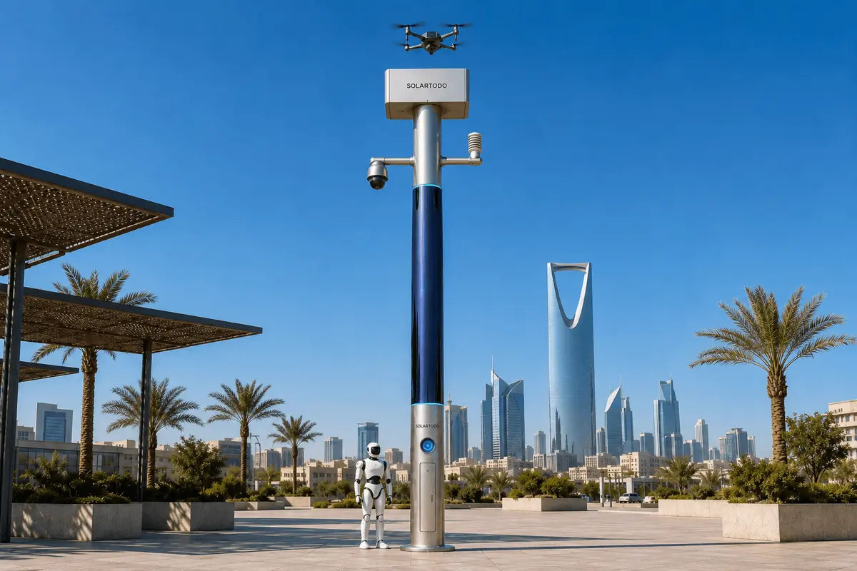
A City AI Pole / SOLARTODO Sentinel Sky Hub is a non-lighting physical-AI urban edge node: an off-grid, battery-backed pole with on-pole sensing, edge compute, drone battery-swap operations, ground robot charging, and command-view workflows. In this Mexico City configuration, it supports transport-campus perimeter patrols while keeping raw video and sensor data processed locally.
1. City Task And Operating Context
Mexico City’s transport estate is not a single clean boundary. Metro stations, bus interchanges, depots, pedestrian bridges, service yards, drainage channels, canalized waterways, maintenance roads, and vendor-heavy public edges form a river-network urban pattern: long linear corridors with many bends, crossings, underpasses, and informal access points. For a transport authority, the operational problem is not only distance. It is discontinuity. A security team may have coverage at gates and platforms, yet still face blind spots along depot walls, service-lane corners, canal-side approaches, parking edges, and late-night pedestrian routes feeding the night economy.
This case study frames a proposed, illustrative SOLARTODO Sentinel Sky Hub configuration for a transport-campus perimeter in Mexico City, subject to final engineering confirmation, site survey, permissions, aviation review, and authority operating rules. The task is to increase planned patrol frequency and perimeter awareness without relying on grid, city, or site power at each node. Sky Hub is positioned here as a city-ai-pole and physical-AI urban edge node, not as a streetscape amenity and not as a lighting asset. It carries no lighting system. Its value is the integration of edge computing, autonomous drone operations, ground robot operations, sensing, energy buffering, and command coordination in one off-grid field node.
The seasonal trigger is the night-economy period: evenings, weekends, events, holiday commerce, and extended station-adjacent activity. During these windows, the transport authority needs more frequent perimeter checks while avoiding constant manual sweeps of low-visibility zones. The proposed deployment mode is a grid-mesh of nodes around the transport campus edge. Each node covers a local sector, shares de-identified event and status metadata with the common-operating-picture view, and can coordinate patrol tasks with adjacent nodes. Raw video and sensor data stay on the pole for local processing; what leaves the pole is limited to event summaries, alerts, health status, mission logs, and other de-identified metadata according to policy.
2. Grid-Mesh Edge Computing Plan
The proposed ops plan places Sky Hub nodes at perimeter points where fixed visibility breaks down: depot corners, canal or drainage-edge approaches, pedestrian bridge landings, service-road entrances, yard-wall setbacks, and shared boundaries between transport property and commercial night-economy areas. The exact count and spacing are not stated here because they require line-of-sight, solar exposure, flight path, civil mounting, radio, and security surveys. The planning principle is that the mesh closes blind spots through overlapping observation sectors and task handoff, not through a single central camera feed.
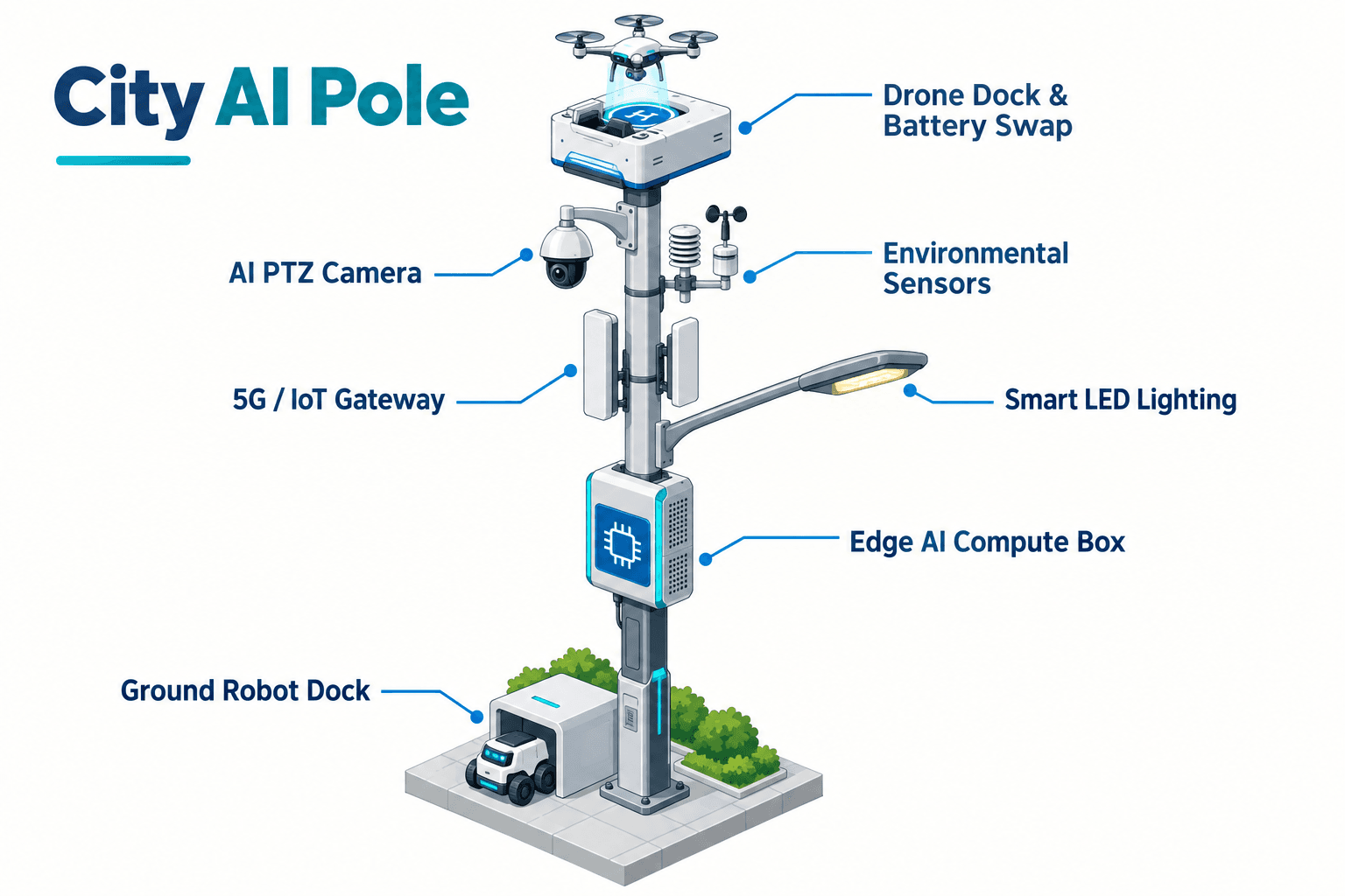
Each node runs OTATODO at the edge on a Jetson-class compute module. Local inference supports anonymous vehicle count, crowd density, intrusion, perimeter awareness, environmental readings, energy budgeting, drone mission scheduling, robot tasking, and event prioritization. The transport command view receives a common operating picture: sector status, event category, confidence band, battery state, patrol queue, drone swap state, robot charging state, and maintenance flags. It is not designed around streaming raw continuous video away from the site.
The data posture is PDPL/LGPD-oriented: local processing by design, policy-gated event metadata export, and a preference for de-identification before transmission. That language matters. It does not claim certification or automatic legal compliance. It gives the authority a technical architecture that can be reviewed against Mexico’s privacy expectations, internal retention policy, procurement requirements, and operating rules.
For Mexico City’s mixed built environment, edge computing also protects operational continuity. A network outage should not erase local awareness. The node can continue sensing, classifying, scheduling, logging, and preserving local evidence records while the command view receives updates when connectivity returns. In a transport-campus perimeter, this is essential because the moments that matter often occur in the least convenient conditions: rain, congestion, events, partial connectivity, or night-shift staffing gaps.
3. Battery-Swap Patrol Frequency Model
The module focus for this deployment is the Sky Hub drone battery hot-swap system. The transport authority’s target KPI is patrol frequency: how often the perimeter sectors can be checked by air and ground assets during the night-economy window. A conventional drone workflow loses time when an operator must retrieve, charge, relaunch, or physically service the aircraft. Sky Hub changes the planning model by making the pole the service point.
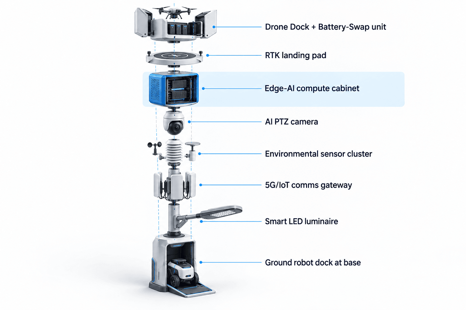
A drone launches from the node for a regional patrol, inspection route, alarm response, or redeployment task. After landing, the rear-service battery exchange system removes the spent pack, places it into a charging bay, indexes a charged pack, inserts it into the aircraft, checks state, records the swap, and queues the next sortie. Multiple battery bays allow several consecutive sorties, subject to weather, flight rules, energy budget, local approval, and maintenance policy. No operator needs to stand at the pole for ordinary relaunch cycles.
The purpose is not to claim unlimited flight or unlimited solar self-sufficiency. The pole is fully off-grid because it combines battery storage with 360-degree wrapped flexible CIGS thin-film replenishment. A vertical 8 m tall, 0.6 m wide cylindrical body carries roughly 15 m² of CIGS, about 2.4-2.7 kWp nameplate. Because a vertical cylinder collects direct sun on its sun-facing projection rather than the full wrap, realistic clear-sky output in a high-irradiance region is roughly 0.8-1.1 kW DC peak and about 6-9 kWh per day. Mexico City’s final yield would require local solar modeling. The planning point is that CIGS replenishes a battery-backed micro-station; high-power drone and robot tasks are buffered by 5-20 kWh-class storage and scheduled by duty cycle.
For the transport authority, the patrol-frequency KPI can be evaluated as planned sorties per night, percentage of target perimeter sectors checked per hour, average time between alarm and aerial verification, number of manual patrols redirected from routine checking to exception handling, and percentage of sorties completed within the approved energy budget.
4. Air-Ground Response Loop
The operating loop follows sensing, authorized assessment and response, edge-compute scheduling, and field operations and maintenance as one common-operating-picture workflow. A PTZ camera with local perception watches for anonymous crowd-density shifts, vehicle movement, intrusion patterns, and perimeter anomalies. The environmental set measures wind speed, wind direction, temperature, humidity, atmospheric pressure, noise, PM10, PM2.5, and illuminance, giving dispatchers and automation rules context before a drone or ground robot is sent.
When the pole detects an anomaly near a campus perimeter blind spot, OTATODO classifies and scores the event locally. The command view presents the event type, sector, time, local confidence band, current energy state, drone readiness, robot readiness, and recommended task. A human operator or authorized rule set can approve the response. The response may dispatch a drone for overhead verification, send a humanoid or service robot for ground-level inspection, or coordinate both when a canal-side approach, yard gate, or bridge landing needs air-ground confirmation.
Ground robot operations are planned around autonomous patrol, alarm response, inspection, air-ground coordination, and return-to-base wireless charging at the pole base. The robot is not treated as a roaming replacement for staff; it is a field asset that extends observation into repeatable patrol routes and brings status back into the common operating picture.
Counter-UAS coordination remains bounded. The pole may detect and track an unauthorized drone using its local sensing and optional partner-sensor inputs; radar is not built into the pole. If authorized by the responsible human authority and operating rules, the node may command its friendly drone to perform soft aerial net-capture or close-approach deterrence. The plan excludes shoot-downs, hard-kill effects, jamming, denial, or autonomous attack. Detection, decision support, authorization, action, and audit remain separated.
5. Procurement And Evaluation Plan
For a Mexico City transport authority, the case for Sky Hub should be evaluated as an operations plan rather than a product datasheet. The recommended procurement lens is: which blind spots are materially reduced, how patrol frequency changes during night-economy peaks, how many routine checks can be automated without weakening human authority, how clearly the system records decisions, and how well the off-grid energy budget supports the intended duty cycle.
A practical evaluation would begin with a site walk, perimeter risk map, solar exposure review, privacy impact review, flight-path and local aviation review, robot route survey, communications survey, and COP integration workshop. The proposed grid-mesh can then be configured sector by sector. Some nodes may emphasize drone sorties. Others may emphasize robot return-and-charge, environmental telemetry, or perimeter awareness. The shared rule is that each node processes locally, exports only de-identified event and status metadata by default, and stays independent of grid or site power.
Success should not be sold as a fixed universal number. Mexico City has microclimates, vertical obstructions, tree canopy, dense public edges, and seasonal rain patterns. The honest B2B commitment is a recomputable model: target patrols per night, target sectors per route, battery reserve policy, solar replenishment estimate, swap-cycle assumptions, human authorization workflow, and audit fields. That is what makes the deployment credible for a transport authority: fewer blind spots by design, higher planned patrol frequency by scheduling, and a clearer chain from edge detection to authorized action to recorded outcome.
System Configuration
| Parameter | Configuration |
|---|---|
| Node type | SOLARTODO Sentinel Sky Hub, pure non-lighting city-ai-pole / physical-AI urban edge node |
| Energy system | fully off-grid battery-backed micro-station with 360-degree wrapped flexible CIGS replenishment and 5-20 kWh-class storage planning |
| Edge AI compute | on-pole Jetson-class inference module running local perception, scheduling, event scoring, and workload management |
| Drone module | autonomous launch, patrol, landing, multi-bay rear-service battery hot-swap, relaunch, mission logs, and fleet health state |
| Ground robot module | autonomous perimeter patrol, inspection, alarm response, air-ground coordination, and wireless charging at pole base |
| Sensing package | AI PTZ for anonymous vehicle count, crowd density, intrusion and perimeter awareness, plus nine-parameter environmental monitoring |
| Data handling | raw video and sensor data stay on the pole; only de-identified event and status metadata may leave by policy |
How It Works
- On-pole sensing flags a perimeter anomaly in a mapped blind-spot sector.
- Edge AI classifies the event locally and sends only de-identified status metadata to the COP.
- A human operator reviews the event, energy state, patrol queue, and recommended response.
- The node dispatches a drone, ground robot, or coordinated air-ground task after authorization.
- OTATODO records mission state, battery-swap status, response outcome, and maintenance flags.
Planning Assumptions (Indicative)
Illustrative planning inputs a buyer can recompute — target metrics, not achieved results. Subject to final engineering confirmation.
| Metric | Planning assumption | Indicative value |
|---|---|---|
| Patrol frequency | one node schedules repeated drone sorties during a night-economy window using automated battery hot-swap | target 4-8 aerial patrols per node per night |
| Manual inspection load | routine perimeter checks shift from fixed walking rounds to exception-led human review and response | target 2-4 routine patrol segments automated per shift |
| Blind-spot review | grid-mesh nodes are placed at corners, bridge landings, service-road edges, canal-side approaches, and yard setbacks after survey | target 80-100% of priority blind-spot sectors assigned to a node or handoff route |
| Energy reserve | drone and robot tasks are scheduled against battery state, weather, solar replenishment forecast, and minimum reserve policy | target 20-30% reserve maintained before non-critical sorties |
| Command workflow | events create structured logs for detect, decide, act, and record steps without exporting raw continuous video | target 100% of authorized responses logged with event metadata |
Deployed Equipment
- SOLARTODO Sentinel Sky Hub off-grid pole body with wrapped flexible CIGS surface
- Battery storage cabinet and power-management system
- On-pole edge compute cabinet running OTATODO
- AI PTZ camera for local perimeter perception
- Nine-parameter environmental monitoring sensor set
- Drone launch and multi-bay battery hot-swap module
- Friendly patrol drone with rear-service swappable battery interface
- Ground robot wireless charging pad at pole base
Frequently Asked Questions
Is Sky Hub a smart streetlight or does it include lighting?
No. In this configuration Sky Hub is a pure non-lighting smart pole and physical-AI edge node. It is not a smart streetlight, is not specified as a lighting asset, and does not rely on lamp heads or luminaires for its value. The deployment case is about edge computing, drone operations, robot operations, sensing, energy storage, and command coordination.
How does the proposed Mexico City grid-mesh reduce blind spots?
The mesh is planned around perimeter discontinuities rather than generic coverage. Nodes are placed after survey at depot corners, canal-side approaches, bridge landings, service-road entrances, and yard-wall setbacks. Each node processes its local sector, contributes event metadata to the common operating picture, and can hand tasks to drones or ground robots without requiring grid power at that point.
Why is battery hot-swap central to the patrol-frequency KPI?
Patrol frequency depends on how quickly a drone can return to service after a sortie. The multi-bay hot-swap module lets a landed drone receive a charged pack through an automated rear-service exchange, then relaunch according to the approved task queue. This changes planning from one-off flights to scheduled consecutive patrols, subject to energy, weather, maintenance, and local operating rules.
Does the system upload raw video to a cloud platform?
The proposed data posture keeps raw video and sensor data on the pole for local processing. The command view receives de-identified event and status metadata, such as event category, sector, time, health, energy state, and mission state. This is PDPL/LGPD-oriented by design, but final compliance language depends on the buyer’s legal review and configured policies.
Can the pole operate without city or site power?
Yes, the proposed Sky Hub configuration is fully off-grid: battery storage plus on-pole CIGS solar replenishment. The solar layer is not described as unlimited self-sufficiency. It is a replenishment source for a battery-backed micro-station, while high-power drone and robot tasks are managed by duty cycle, storage capacity, reserve policy, and final site-specific solar modeling.
What does Counter-UAS coordination mean in this plan?
It means the node may detect and track an unauthorized drone and, only after human authorization and within operating rules, command its friendly drone for soft aerial net-capture or close-approach deterrence. The plan excludes shoot-downs, hard-kill methods, RF or GNSS jamming, denial effects, and autonomous attack. Radar, if used, would be an optional partner-sensor input, not built-in pole hardware.
Are the KPIs claimed achieved results?
No. The patrol-frequency, blind-spot, reserve, and workflow figures in this case study are illustrative planning inputs for buyer evaluation. They are not claimed field results, certified performance numbers, or guarantees. A transport authority would recompute them after site survey, route design, airspace review, privacy review, and final engineering confirmation.
Explore Further
- City AI Pole / smart streetlight product line
- More smart-city deployment cases
- Talk to our engineering team
Planning a similar physical-AI deployment for streets, campuses or public spaces? Request an engineering consultation