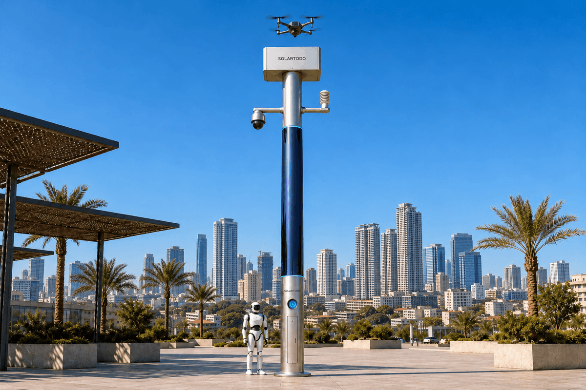
A City AI Pole is a physical-AI urban edge node combining local computing, sensing, autonomous drone support and ground robot operations. SOLARTODO Sentinel’s Sky Hub is a fully off-grid, non-lighting pole running OTATODO at the edge. This proposed Manila deployment supports a water authority’s transport-hub environmental inspections, retaining raw data on each pole and sharing only de-identified event and status metadata.
1. Incident brief: a holiday drainage alert needs defensible evidence
The review begins with an illustrative incident: during an Undas holiday departure period, a water authority receives reports of standing water beside a Manila transport interchange. The proposed inspection area connects terminal approaches, a drainage channel and a maintenance access route toward the Pasig River corridor. These are planning locations, not a claimed customer installation. The operational question is whether visible water indicates an obstructed drain requiring intervention, temporary surface accumulation or an observation that needs further checking.
Holiday operations make evidence collection the central problem. A report can identify a concern without establishing its location, persistence or maintenance significance. An aerial image may show an obstruction but leave the ground approach unclear. Repeated reports can also describe the same event. Sending crews against every unverified alert consumes inspection capacity and can complicate access around passenger movements.
Seasonal conditions belong in that assessment. PAGASA describes the Philippine rainy season as June through November, making rainfall-related inspection a reasonable planning concern for this holiday window; this does not predict weather on a particular day. Source: PAGASA climate overview.
The proposed response uses SOLARTODO Sentinel Sky Hub nodes as a spatial grid with mesh communications. Here, grid-mesh describes deployment topology, with every pole fully off-grid. The incident review follows how local edge computing would assemble evidence, support an authorized inspection and produce an auditable maintenance decision. False-alarm rate is the evaluation focus. No Manila deployment results, customer endorsement or achieved reduction are asserted.
2. Evidence reconstruction: classify locally before escalating
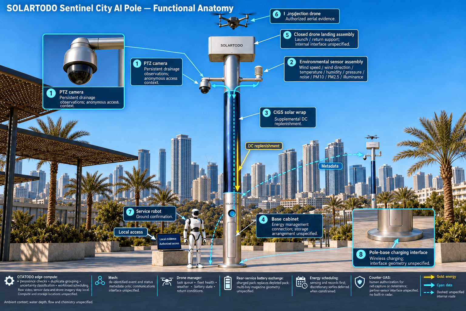
In the proposed incident sequence, a pole’s PTZ camera identifies a persistent visual change near a drainage opening. OTATODO schedules local inference, checks observations across time and associates the candidate event with a defined inspection zone. Anonymous vehicle counts and crowd-density estimates provide access context. Intrusion and perimeter awareness help distinguish an environmental inspection from activity inside a restricted maintenance area, without identifying people or reading vehicle plates.
The integrated environmental package measures wind speed, wind direction, temperature, humidity, atmospheric pressure, noise, PM10, PM2.5 and illuminance. These readings contextualize visibility, exposure and inspection conditions. They do not measure water chemistry, drainage flow or water depth. A visual indication therefore remains a candidate condition until appropriate inspection establishes what happened.
The edge-compute module is the organizing capability. It groups repeated observations, separates uncertain classifications from actionable alerts and retains the relationship between the original trigger and subsequent assessment. Across the mesh, de-identified event identifiers and status summaries support correlation of reports from adjacent zones. Each pole retains its own raw video and sensor data; neighboring nodes do not exchange raw streams.
The common-operating-picture command view presents location, classification, confidence, observation time, equipment availability and authorization state. Remote reviewers receive de-identified metadata, including reasons for escalation or uncertainty. Authorized examination of original evidence occurs through access at the originating pole. This distinction matters for the water authority: a concise event summary supports dispatch, while a traceable local record preserves the basis for later incident review.
3. Authorized response: low-altitude inspection and ground confirmation
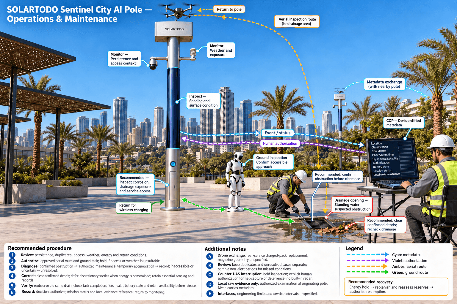
Once an authorized reviewer determines that additional evidence is needed, the drone operations manager selects an approved low-altitude inspection route. It checks the task queue, fleet health, weather inputs, battery state and return conditions. Within authorized operating arrangements, the drone launches, inspects the drainage corridor, returns and can be redeployed without an operator stationed at the pole. Passenger areas and vehicle movements remain constraints on route selection and launch authorization.
After landing, a multi-bay battery magazine performs an automated rear-service battery exchange. A charged pack replaces the depleted pack, enabling another scheduled sortie. Multiple bays support consecutive sorties within available charged-pack inventory, energy reserves and operating limits. Route planning, charge-and-swap state transitions and mission logs remain coordinated by the on-pole manager. Drone raw imagery is retained at its originating pole; only de-identified findings and mission status may leave.
A service robot provides a complementary ground inspection. It can patrol an authorized maintenance route, respond to an alarm, examine an accessible drainage approach and coordinate observations with the aerial task. It returns to the pole base for wireless charging. The incident record distinguishes an observed obstruction from a suspected obstruction and records inaccessible areas as unresolved rather than treating an incomplete inspection as confirmation.
Counter-UAS coordination remains a separate, human-authorized capability. If an unauthorized drone interrupts the inspection, the node can detect and track it and coordinate its own friendly drone for soft aerial net-capture or close-approach deterrence. Any mitigation requires explicit human authorization and an appropriate operating envelope. Radar is not built into the pole; optional partner-sensor inputs can supplement detection.
4. Engineering review: mesh continuity within a finite energy budget
Sky Hub is a pure smart pole with no lighting system. Its proposed Manila configuration combines sensing, edge computing, drone support and robot operations on a fully off-grid micro-station. Each pole uses on-pole solar replenishment and battery storage, with no grid, city or site power. Mesh connectivity provides coordination between nodes without changing that independent energy architecture.
The cylindrical body is approximately 8 metres tall and 0.6 metres wide, carrying about 15 square metres of 360-degree-wrapped flexible CIGS thin-film solar. Its approximately 2.4–2.7 kWp nameplate rating must be distinguished from actual production. Direct sunlight reaches the cylinder’s sun-facing projection rather than the entire wrapped surface simultaneously.
For a high-irradiance reference such as Saudi Arabia, realistic clear-sky production is roughly 0.8–1.1 kW DC peak and about 6–9 kWh per day, with peaks generally in mid-morning or afternoon rather than noon. These figures are not a Manila yield forecast. Local shading, cloud cover, orientation, temperature and installation geometry require assessment before setting an operating schedule.
The solar wrap supplies supplemental replenishment. Storage in the 5–20 kWh class buffers high-power drone and robot tasks; its usable energy and replenishment remain finite. OTATODO therefore schedules duty cycles against compute demand, communications, sensing, battery charging and reserve requirements. During constrained energy periods, the proposed policy prioritizes essential sensing and incident records while deferring discretionary sorties. Final engineering must confirm storage sizing, structural wind loading, drainage exposure, corrosion protection, thermal management and maintenance access. A credible incident review records an energy-related deferral as a service limitation, not as a completed inspection.
5. Review decision: evaluate false alarms without hiding missed events
The water authority’s proposed acceptance process starts with a shared labeling rule. An actionable alert requires evidence of a condition warranting the agreed inspection or maintenance response. A false alarm is an escalated alert subsequently confirmed as non-actionable under that rule. Unresolved cases stay separate until adjudication. Duplicate notifications are tracked separately so that consolidation does not artificially improve the classification score.
For operational reporting, the false-alarm share is confirmed non-actionable escalations divided by all adjudicated escalations. If the buyer requires the formal false-positive rate, the evaluation must additionally label negative observation windows and calculate false positives divided by false positives plus true negatives. Naming both denominators prevents different teams from reporting incompatible rates under the same label.
Compare the existing review process with the proposed edge-assisted workflow across comparable holiday operating windows. Hold the incident definition, inspection zones and adjudication rules constant. Examine whether persistence checks, duplicate grouping and authorized aerial confirmation reduce unnecessary escalation. Also sample non-alert periods and review unresolved cases to expose missed conditions. A lower false-alarm figure is not sufficient if inspection completeness deteriorates.
The review closes with a maintenance decision, an accountable authorizer and a locally retained evidence reference. The COP records sensing, authorized assessment and response, edge-compute scheduling, and field operations and maintenance as one continuous loop. SOLARTODO’s established in-service capabilities form the proposed configuration; Manila installation details and acceptance thresholds remain subject to final engineering confirmation. Data handling is designed for local processing and is PDPL/LGPD-oriented, without implying certification or verified Philippine compliance.
System Configuration
| Parameter | Configuration |
|---|---|
| Pole and deployment topology | Non-lighting cylindrical Sky Hub, approximately 8 m tall and 0.6 m wide; spatial grid with mesh communications; fully off-grid. |
| Edge AI compute | On-pole inference module running OTATODO, with local workload scheduling, event correlation and raw-data storage. |
| Security sensing | PTZ camera with local perception for anonymous vehicle count, crowd density, intrusion and perimeter awareness. |
| Environmental monitoring | Nine measurements: wind speed, wind direction, temperature, humidity, atmospheric pressure, noise, PM10, PM2.5 and illuminance. |
| Air and ground operations | Autonomous drone landing and launch support, multi-bay rear-service battery exchange, mission manager, service robot and base wireless charging. |
| Energy system | Approximately 15 m² wrapped flexible CIGS, approximately 2.4–2.7 kWp nameplate; 5–20 kWh-class storage, subject to final sizing. |
| Counter-UAS coordination | Detection and tracking with human-authorized friendly-drone soft net-capture or close-approach deterrence; no built-in radar. |
How It Works
- On-pole perception flags a persistent drainage-area anomaly and retains raw evidence locally.
- Edge compute correlates observations, groups duplicates and publishes de-identified event metadata.
- A human reviewer authorizes an inspection after checking access, weather and energy status.
- The node schedules a low-altitude drone inspection and any required ground robot confirmation.
- The water authority adjudicates the event and assigns maintenance or further investigation.
- The COP records authorization, mission status and the originating pole’s local evidence reference.
Planning Assumptions (Indicative)
Illustrative planning inputs a buyer can recompute — target metrics, not achieved results. Subject to final engineering confirmation.
| Metric | Planning assumption | Indicative value |
|---|---|---|
| Illustrative false-alarm share | ILLUSTRATIVE ONLY: assume 100 adjudicated escalations, including 20 confirmed non-actionable cases; these are hypothetical evaluation inputs. | 20 ÷ 100 × 100 = 20% illustrative false-alarm share, not an achieved result or acceptance threshold. |
| Manual review effort | ILLUSTRATIVE ONLY: assume 100 escalations require 6 minutes of review each during one evaluation window. | 100 × 6 = 600 minutes, or 10 hours of hypothetical review effort. |
| Duplicate-review opportunity | ILLUSTRATIVE ONLY: assume 20 duplicate notifications would each require 4 minutes of separate review. | 20 × 4 = 80 minutes of potentially avoidable review; validate consolidation accuracy before counting any benefit. |
| Non-alert sampling effort | ILLUSTRATIVE ONLY: review 10 non-alert observation windows per day for 5 days, allowing 3 minutes per window. | 10 × 5 × 3 = 150 minutes of planned sampling to investigate missed conditions. |
Deployed Equipment
- Non-lighting Sky Hub cylindrical pole with wrapped flexible CIGS solar.
- Battery storage cabinet with energy-management controller.
- On-pole edge-compute module and local evidence storage.
- PTZ camera and nine-variable environmental sensor assembly.
- Inspection drone with automated rear-service battery interface.
- Multi-bay drone battery magazine and landing assembly.
- Service robot with pole-base wireless charging interface.
- Mesh communications equipment for de-identified event and status exchange.
Frequently Asked Questions
Is this an actual Manila customer deployment?
This article describes a proposed Manila configuration through an illustrative incident review. It does not identify a customer installation or claim achieved local results. SOLARTODO Sentinel’s in-service capabilities provide the product basis, while site selection, permissions, operating procedures, energy sizing and evaluation thresholds require project-specific confirmation.
Does grid-mesh mean the poles require electricity from the city?
Grid-mesh describes the spatial arrangement and communications topology. Each pole is fully off-grid, using wrapped CIGS solar replenishment and battery storage without grid, city or site power. Available energy still limits duty cycles, so drone sorties, robot charging and compute workloads require scheduling against a verified local energy budget.
How can the water authority review evidence when raw data stays on the pole?
The remote command view receives only de-identified event and status metadata, including classifications, timestamps, authorization records and mission outcomes. Raw video and sensor data remain on the originating pole. Authorized detailed evidence examination uses local access there, with retention periods, access permissions and record-integrity procedures specified during engineering.
Can the environmental sensors prove a drainage blockage or contaminated water?
The nine-variable package measures atmospheric and ambient environmental conditions, including particulates, wind and illuminance. It does not directly measure water depth, flow or chemistry. Camera observations and aerial or ground inspections support assessment, while any water-quality conclusion requires separately specified sampling or instrumentation and an appropriate verification procedure.
How should buyers evaluate false-alarm performance?
Agree the event definition and denominator before evaluation. Report confirmed non-actionable escalations as a share of adjudicated alerts, and use labeled negative observation windows if calculating formal false-positive rate. Track duplicates, unresolved cases and missed conditions separately. Compare equivalent operating windows rather than presenting hypothetical calculations as measured improvement.
Explore Further
- City AI Pole / smart streetlight product line
- More smart-city deployment cases
- Talk to our engineering team
Planning a similar physical-AI deployment for streets, campuses or public spaces? Request an engineering consultation