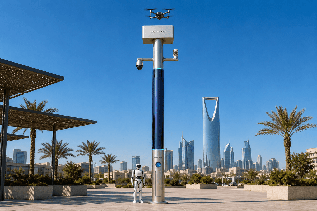
A City AI Pole / SOLARTODO Sentinel Sky Hub is a fully off-grid, non-lighting physical-AI edge node that combines battery storage, 360-degree wrapped CIGS solar replenishment, local AI compute, sensing, drone-nest operations, and robot support. In this Manama configuration, it helps emergency-management teams inspect transport-hub zones and collect de-identified evidence after heatwave-linked disruption.
Manama Emergency Context
Manama is a compact, high-mobility Gulf capital where transport corridors, port-adjacent logistics, airport access routes, waterfront districts, causeway movements, parking structures, service roads, and critical-infrastructure perimeters sit close together. During a severe heatwave, disruption can appear as equipment faults, stalled vehicles, exposed work crews, access-control incidents, crowding near transit nodes, or damage after emergency response activity. For emergency-management stakeholders, the problem is not only response speed. It is evidence collection: knowing what happened, where access is blocked, what changed between inspections, and which assets need priority attention before normal operations resume.
This case study presents a proposed, subject-to-final-engineering-confirmation configuration for deploying SOLARTODO Sentinel Sky Hub poles as post-disaster infill nodes in Manama transport-hub zones. The objective is not to replace control rooms, patrol teams, or aviation rules. The objective is to add localized physical-AI capacity at the edge where fixed infrastructure may be unavailable, overloaded, or too slow to extend after an incident. Each Sky Hub operates as a mature city edge node with an integrated drone nest, local perception, environmental sensing, battery-backed power, and a common-operating-picture command view.
The deployment mode is post-disaster infill: place off-grid nodes at priority gaps after a heatwave-linked emergency, planned transport interruption, infrastructure fault, or perimeter incident. Because the system is designed to operate without grid, city, or site power, placement can focus on coverage and safety geometry rather than trenching, cabinet power, or immediate utility availability. For a buyer, the primary KPI is coverage: how much priority inspection work can be made observable, repeatable, and auditable per node, per duty cycle, without sending personnel into every low-value or unsafe inspection location first.
Deployment Architecture
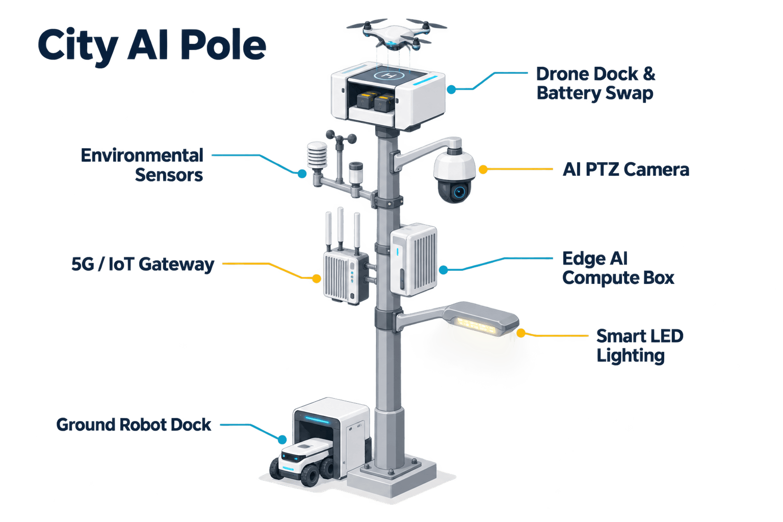
The proposed Manama architecture centers on the Sky Hub pole as a physical-AI urban edge node, not as a conventional amenity asset. The pole body hosts the power, compute, sensing, drone operations, and robot support stack in a single field-deployable form. Its 360-degree wrapped flexible CIGS thin-film layer provides supplemental solar replenishment around a vertical cylindrical body of roughly 8 m height and 0.6 m width, with about 15 m2 of active wrap and an approximate 2.4-2.7 kWp nameplate surface. In real operation, the whole wrap does not face direct sun at once. A realistic high-irradiance clear-sky planning range is about 0.8-1.1 kW DC peak, typically peaking mid-morning and mid-afternoon rather than at noon, and about 6-9 kWh/day.
That energy model matters for credibility. Sky Hub is fully off-grid because it combines on-pole replenishment with battery-backed storage, not because the vertical solar surface alone promises unlimited operation. High-power drone and robot tasks are buffered by 5-20 kWh-class storage and scheduled by duty cycle. The command workflow can defer non-urgent sorties, prioritize emergency inspection routes, and preserve reserve energy for response tasks. This is especially relevant during heatwaves, when cooling loads, battery behavior, and sortie planning require conservative operational margins.
For the transport-hub archetype, nodes would be positioned to observe approaches, access roads, staging areas, exposed perimeter edges, interchanges, service yards, and emergency vehicle routes. The drone-nest module provides launch, return, battery hot-swap, redeployment, mission logging, fleet health status, and route planning. A landed drone can receive an automated rear-service battery exchange from a multi-bay magazine, allowing several consecutive sorties subject to route length, weather, airspace permission, payload, and local operating rules. The on-pole PTZ camera and environmental suite provide context before and after each sortie. Ground robot operations can support base-area patrol, alarm response, inspection, air-ground coordination, and return-to-base wireless charging where suitable surfaces and procedures are confirmed.
Evidence Workflow
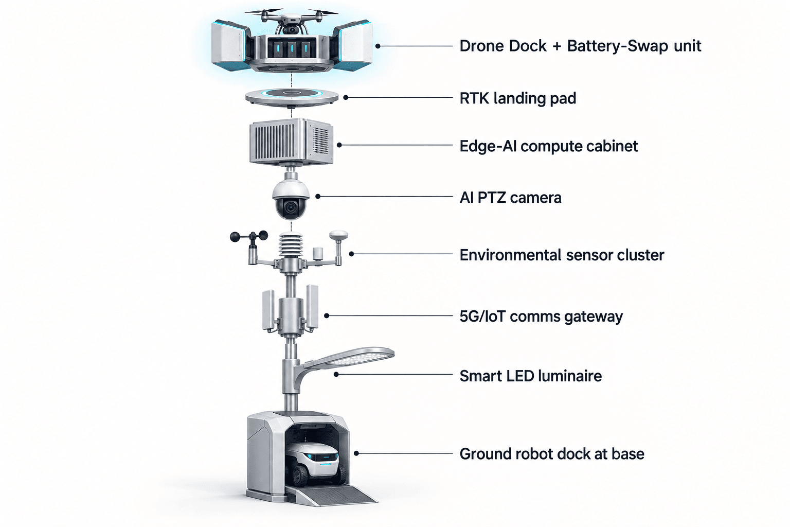
For Manama emergency management, the central task is building a defensible operational record without moving raw sensitive data around the city. Sentinel handles this through local edge processing. Raw video and sensor streams stay on the pole and are processed locally. Only de-identified event and status metadata may leave the node for the COP view, such as event type, confidence band, timestamp, node health, route status, environmental readings, and operator decision records.
The operational loop follows sensing, authorized assessment and response, edge-compute scheduling, and field operations and maintenance. A heatwave-triggered inspection might begin with a PTZ sweep showing unusual vehicle stoppage near a transport approach, elevated noise, crowd-density change, or intrusion at a restricted service perimeter. The edge module classifies the event locally, scores urgency, and presents an evidence card to an authorized operator. The operator can approve a drone sortie, request another camera angle, dispatch a ground robot for local confirmation, or mark the event for manual follow-up.
Once authorized, the drone nest assigns a route that emphasizes evidence collection rather than broad surveillance. The sortie can capture low-altitude inspection context for infrastructure condition, access obstruction, queue formation, exposed equipment, perimeter breach indicators, or post-response scene status. After landing, the battery hot-swap magazine supports redeployment when the task queue requires additional passes. The mission log records route intent, command approval, swap state, environmental readings, event metadata, and maintenance status. This creates a structured record for emergency-management review without claiming face recognition, licence-plate recognition, or centralized upload of raw imagery.
Counter-UAS coordination is handled as a non-lethal, human-authorized workflow. If an unauthorized drone is detected and tracked through local or approved partner-sensor inputs, the Sky Hub can coordinate its own friendly drone for soft aerial net-capture or close-approach deterrence after authorization. Radar, where used, is treated only as optional partner-sensor input, not pole hardware. The goal is perimeter awareness and controlled response coordination, not autonomous attack.
Coverage ROI Analysis
The economic framing for this Manama use case should be coverage ROI, not a claim of achieved savings. The buyer can evaluate whether one off-grid node increases the portion of priority assets that can be inspected, re-inspected, and documented during a defined emergency window. Coverage can be expressed as target route count, inspection frequency, scene revisit interval, percentage of priority checkpoints observed, or number of evidence packages created for supervisor review.
Manual inspection after heatwave disruption is often constrained by access, safety, daylight, staffing, and documentation consistency. A Sky Hub drone nest changes the planning equation by moving the first look to an on-site autonomous asset. Emergency-management teams can reserve human deployment for validated exceptions, hazardous conditions, or recovery work that requires direct intervention. The value is strongest where the same corridor or hub must be checked repeatedly: before reopening, after a crowd movement, after equipment reset, during perimeter stabilization, or while coordinating with field maintenance.
The proposed ROI model should remain recomputable. Planners can start with round target inputs: inspection routes per week automated, priority checkpoints per route, manual visits avoided, evidence packages reviewed, and operator escalations per event class. They should also include limits: hot weather duty cycles, storage reserve, drone permissions, local airspace constraints, pole placement, line-of-sight, network availability, and maintenance access. Because the system is fully off-grid, the model should include battery reserve policy and solar replenishment assumptions separately. The CIGS layer provides useful replenishment, but drone and robot workloads must be scheduled against storage, weather, and mission priority.
For B2B procurement, this keeps the case credible. The Sky Hub is not sold here as a citywide instant transformation or a nation-scale rollout. It is an infill capability for specific transport-hub gaps where coverage, evidence quality, and response coordination matter after heatwave stress. Final engineering should confirm siting, permissions, route envelopes, storage sizing, communications, maintenance windows, and local data-governance requirements before any committed deployment plan.
Buyer Fit
The best-fit stakeholder is an emergency-management organization responsible for coordinating post-incident visibility across mixed transport and infrastructure zones. The buyer may work with transport operators, port or logistics managers, police, civil defense, district authorities, and facility owners, but the operational requirement is common: create a reliable field picture quickly, without waiting for permanent powered infrastructure or sending teams into every location first.
For Manama, the practical deployment thesis is to use Sky Hub nodes as off-grid observation and action points at selected transport-hub edges. They provide a drone-ready and robot-ready field base, local AI triage, environmental context, and command-view integration. The nine-in-one capability set remains integrated but task-led: the pure smart pole hosts the functions; the drone nest performs inspection sorties; hot-swap extends redeployment; operations management governs routes, queues, logs, and health; robots support ground-level response; PTZ sensing supports anonymous counts and perimeter awareness; environmental monitoring adds heatwave and air-quality context; edge compute keeps raw data local; and Counter-UAS coordination adds authorized, non-lethal protective action when needed.
The procurement question is therefore not whether the city needs another generic smart asset. It is whether emergency managers need a repeatable off-grid method to inspect, document, and coordinate action in transport-hub zones after heatwave disruption. Where the answer is yes, SOLARTODO Sentinel Sky Hub gives buyers a concrete node configuration and measurable coverage framework, while leaving final quantities, node spacing, aviation approvals, operating procedures, and integration scope subject to site engineering.
System Configuration
| Parameter | Configuration |
|---|---|
| Pole configuration | Pure non-lighting smart pole; fully off-grid physical-AI edge node with battery storage and 360-degree wrapped flexible CIGS solar replenishment |
| Drone nest | Autonomous launch, landing, return, task redeployment, route planning, mission logs, fleet health, and multi-bay rear-service battery hot-swap |
| Edge AI compute | Jetson-class on-pole inference module, Orin- or Thor-class, scheduling local workloads while keeping raw video and sensor data on the pole |
| Security sensing | AI PTZ camera for anonymous vehicle count, crowd density, intrusion, perimeter awareness, and operator-reviewed event evidence |
| Environmental monitoring | Wind speed, wind direction, temperature, humidity, atmospheric pressure, noise, PM10, PM2.5, and illuminance |
| Energy system | ~15 m2 vertical CIGS wrap, ~2.4-2.7 kWp nameplate, realistic clear-sky ~0.8-1.1 kW DC peak and ~6-9 kWh/day in high-irradiance planning conditions, buffered by 5-20 kWh-class storage |
| Command view | Common-operating-picture dashboard for sensing, authorized assessment, response approval, edge workload scheduling, field O&M, and de-identified metadata review |
How It Works
- On-pole PTZ and environmental sensors flag an anomaly near a transport-hub access route.
- Edge AI classifies the event locally and creates a de-identified evidence card for the COP.
- An authorized operator approves a drone inspection route or assigns ground robot confirmation.
- The drone nest launches, records route status, lands, and performs battery hot-swap if redeployment is required.
- The COP stores mission logs, event metadata, operator decisions, energy state, and O&M status for review.
Planning Assumptions (Indicative)
Illustrative planning inputs a buyer can recompute — target metrics, not achieved results. Subject to final engineering confirmation.
| Metric | Planning assumption | Indicative value |
|---|---|---|
| Inspection coverage | Drone sorties cover selected transport-hub checkpoints that would otherwise require repeated manual visual inspection | ~20-40 priority checkpoints per operating cycle targeted |
| Manual patrol displacement | Automated low-altitude inspection provides first-look evidence before teams are dispatched to exceptions | ~5-10 manual first-look patrols per week targeted for automation |
| Evidence packages | Each approved event or route produces a structured supervisor-review record with de-identified metadata and retained local raw data | ~10-30 reviewable evidence packages per week planned |
| Redeployment continuity | Multi-bay battery hot-swap supports consecutive authorized sorties when storage reserve and weather limits allow | ~3-6 consecutive short sorties planned before maintenance review |
| Energy reserve | High-power drone and robot tasks are scheduled against battery reserve, solar replenishment, heat conditions, and priority class | 5-20 kWh-class storage sized per site duty cycle |
Deployed Equipment
- SOLARTODO Sentinel Sky Hub non-lighting pole body
- 360-degree wrapped flexible CIGS thin-film solar layer
- 5-20 kWh-class battery storage cabinet
- Autonomous drone nest with multi-bay battery hot-swap magazine
- AI PTZ camera and local perception stack
- Nine-parameter environmental sensor suite
- Jetson-class edge AI compute module
- Ground robot wireless charging interface at pole base
Frequently Asked Questions
Is the Manama deployment described here an achieved project result?
No. This is a proposed and illustrative B2B configuration for emergency-management planning in Manama, subject to final engineering confirmation. It does not claim achieved results, deployed quantities, certified performance, named customer adoption, fixed coverage area, or measured detection rates. The KPI values are planning inputs that a buyer can recompute.
Why is the transport-hub scenario a strong fit for Sky Hub?
Transport-hub zones concentrate movement, infrastructure, restricted access, service roads, and public-safety pressure in a small operating area. After a heatwave-related disruption, emergency managers need repeatable evidence collection without sending personnel everywhere first. A drone-nest edge node can inspect selected routes, document conditions, and support triage from an off-grid field position.
Does the pole upload raw video to a central platform?
No. The data-handling design keeps raw video and sensor data on the pole for local processing. The COP receives de-identified event and status metadata, such as event type, timestamp, route state, environmental readings, energy condition, and operator decisions. This is PDPL/LGPD-oriented architecture, not a claim of formal certification.
How should buyers interpret the solar and battery claims?
Sky Hub is designed as fully off-grid because battery storage buffers the operating workload while the wrapped CIGS layer replenishes energy. The vertical solar surface should be planned realistically at about 0.8-1.1 kW DC clear-sky peak and roughly 6-9 kWh/day in high-irradiance conditions, not as unlimited self-sufficiency.
What does the drone battery hot-swap module change operationally?
The multi-bay battery magazine allows a landed drone to receive a charged pack through automated rear-service exchange and return to tasking when authorized. This supports consecutive inspection sorties for evidence collection, provided weather, storage reserve, maintenance status, airspace permissions, and local operating procedures allow continued deployment.
Does Sentinel perform face or licence-plate recognition?
No active face recognition or licence-plate recognition is claimed for this configuration. The security-sensing workflow is framed around anonymous vehicle count, crowd density, intrusion, and perimeter awareness. Events are processed locally, reviewed through the command workflow, and represented outside the pole only as de-identified metadata where appropriate.
How is Counter-UAS handled in this configuration?
Counter-UAS coordination is non-lethal and human-authorized. The node may detect and track an unauthorized drone, then command its own friendly drone to perform soft aerial net-capture or close-approach deterrence after approval. Radar is not built into the pole; where relevant, it is only an optional partner-sensor input.
Explore Further
- City AI Pole / smart streetlight product line
- More smart-city deployment cases
- Talk to our engineering team
Planning a similar physical-AI deployment for streets, campuses or public spaces? Request an engineering consultation