Smart Agriculture Monitoring System Design Guide
SOLARTODO Editorial Team
Solar Energy & Infrastructure Expert Team
Watch the video
TL;DR
The best smart agriculture monitoring systems combine fixed sensors, drone imaging, and automated alerts into one workflow. For 20-50 ha farms, use 10-minute sensor intervals, drone flights every 3-7 days, and 3-level alerts linked to irrigation and disease response. This approach can support 10-50% water savings, around 30% lower pesticide use, and typical payback in 2-5 years for high-value crops.
Smart agriculture monitoring systems combine field sensors, drones, and automated alerts to improve decisions across 20-50 ha farms with 10-minute data intervals, LoRaWAN or 4G links, and up to 15-50% water savings when workflows are designed correctly.
Summary
Smart agriculture monitoring systems combine field sensors, drones, and automated alerts to improve decisions across 20-50 ha farms with 10-minute data intervals, LoRaWAN or 4G links, and up to 15-50% water savings when workflows are designed correctly.
Key Takeaways
- Define monitoring zones at 5-10 ha resolution to match irrigation, terrain, and crop variability before selecting sensors or drone routes.
- Combine fixed IoT sensing at 10-minute intervals with drone flights every 3-7 days to capture both continuous trends and high-resolution imagery.
- Use LoRaWAN for 5-15 km low-power field coverage and 4G LTE where image uploads, remote sites, or faster backhaul are required.
- Set alert thresholds with at least 3 layers—warning, action, and critical—to reduce false alarms and shorten response time by 2-24 hours.
- Size power systems for year-round autonomy using solar supply, IP67/IP68 devices, and battery backup sized for at least 3-5 low-sun days.
- Integrate weather, soil, pest, disease, and drone imagery into 1 cloud dashboard with API export to irrigation or farm management systems.
- Compare ROI against manual scouting by tracking 10-50% water savings, about 30% pesticide reduction, and 15-25% yield improvement in suitable crops.
- Buy through a three-tier model—FOB, CIF, or EPC turnkey—and use volume pricing of 5%, 10%, and 15% discounts at 50+, 100+, and 250+ units.
Why Integrated Smart Agriculture Monitoring Matters
Integrated smart agriculture systems deliver better farm decisions by combining 10-minute sensor data, 3-7 day drone imaging, and automated alerts across 20-50 ha blocks where microclimate and soil variability directly affect yield.
Designing a smart agriculture monitoring system is not just about buying sensors or drones. The real value comes from building a decision workflow that links field measurements, aerial imagery, and alerts to specific operational actions such as irrigation, disease scouting, fertigation, and labor dispatch. For B2B buyers, the system must be evaluated as infrastructure: communications, power, cloud software, maintenance, and response protocols matter as much as hardware.
According to the International Energy Agency, "digitalization is becoming central to improving energy and resource efficiency across sectors," and agriculture is one of the clearest examples of that shift. In practice, farms that rely only on manual scouting often miss rapid changes in leaf wetness, localized irrigation failure, or disease spread between field visits. A well-designed architecture reduces this delay from days to hours.
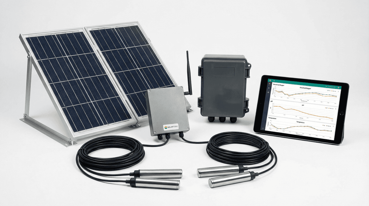
SOLAR TODO positions smart agriculture as field-deployable decision infrastructure for commercial farms, estates, reclamation projects, and GAP-driven operations. Typical deployments combine weather stations, multi-depth soil probes, gateways, cloud analytics, and solar-powered edge devices. In higher-value crops, drone-based monitoring adds a critical spatial layer that fixed sensors alone cannot provide.
According to IRENA (2023), digital tools and renewable-powered infrastructure can improve operational efficiency and resilience in distributed energy applications, which is directly relevant for off-grid agricultural monitoring. According to NREL (2024), site-specific data quality strongly affects performance modeling and operational decisions, a principle that applies equally to irrigation and crop monitoring. These findings support a design approach that prioritizes measurement accuracy, redundancy, and actionability.
System Architecture and Drone Integration Best Practices
The most effective architecture uses 1 professional weather station, distributed soil nodes, 1-2 gateways, and drone surveys every 3-7 days to cover 20-50 ha with both continuous and spatially rich data.
A robust smart agriculture monitoring system should be designed in layers. The first layer is fixed sensing: weather, soil moisture, soil temperature, EC, pH, water quality, pest traps, or spore monitoring depending on crop type. The second layer is communications: LoRaWAN for low-power field collection or 4G LTE for broader backhaul and image-heavy applications. The third layer is analytics and alerting: cloud dashboards, threshold logic, trend analysis, and API integration.
Drone integration should not replace fixed sensors. Instead, it should validate and extend them. Fixed sensors answer what is happening over time at a point; drones answer where it is happening across the field. This distinction is essential when designing systems for tea gardens, medicinal crops, orchards, or desert reclamation sites where slope, canopy density, and irrigation uniformity vary significantly.
Core hardware layers
A commercial design usually includes the following components:
- 1 professional weather station measuring about 10 parameters such as temperature, humidity, rainfall, wind speed, wind direction, pressure, solar radiation, and evapotranspiration
- 6-12 soil monitoring points for 20-50 ha, depending on crop variability and irrigation zoning
- 1-2 gateways using LoRaWAN or 4G LTE
- Solar-powered edge devices with battery autonomy for continuous operation
- 1 cloud platform with dashboards, alarms, user roles, and API access
- Optional AI pest traps, disease spore sensors, or multispectral leaf scanners
- Drone payloads using RGB, multispectral, or thermal cameras depending on use case
Drone mission design
Drone deployment is most effective when flight planning follows agronomic triggers rather than arbitrary schedules. A practical baseline is weekly flights during stable conditions and 2-3 flights per week during disease-prone or irrigation-critical periods. Resolution should be selected based on the decision required: stand count and drainage mapping need different image detail than canopy stress detection.
Best practices include:
- Fly at consistent altitude and overlap to preserve comparability across time
- Align missions with irrigation cycles, rainfall events, or disease-risk windows
- Use ground control points where high geospatial repeatability is required
- Link image outputs to sensor timestamps for better diagnosis
- Trigger ad hoc flights after alerts such as abnormal soil drying, blocked drip lines, or disease signatures
According to IEEE (2018), interoperability is critical when distributed systems exchange operational data across devices and platforms. In agriculture, this means drone imagery, gateway logs, sensor data, and irrigation controls should be normalized into one operational model rather than kept in separate software silos.
SOLAR TODO can support this architecture through configurable smart agriculture packages, including systems similar to Tea Garden Precision Monitoring 30ha and Desert Reclamation Solar+Agriculture 50ha, where weather, soil, disease, and communications layers are already structured for field deployment.
Alert System Design and Response Workflow
The best alert systems use 3 threshold levels, 2 communication channels, and response rules tied to specific field actions so teams can act within 30 minutes to 24 hours depending on severity.
An alert system fails when it produces too many alarms, unclear priorities, or no assigned response owner. For B2B farm operations, alerts should be designed around operational decisions, not raw sensor values alone. A soil moisture drop matters only if it occurs in a critical growth stage, in a specific irrigation zone, and persists beyond expected evapotranspiration.
A practical framework uses three levels:
- Warning: early deviation from target range, monitor trend and prepare response
- Action: threshold crossed, dispatch field check or remote correction
- Critical: immediate risk to crop, equipment, or compliance, escalate to management
Recommended alert categories
The most useful categories are:
- Weather alerts: frost risk, heat stress, high wind, heavy rain
- Soil alerts: moisture deficit, waterlogging, root-zone temperature shift, EC drift
- Irrigation alerts: pressure loss, pump failure, blocked line, abnormal flow duration
- Disease alerts: leaf wetness risk, spore count rise, multispectral stress anomaly
- Security alerts: device offline, enclosure opened, battery low, gateway communication loss
According to FAO (2022), irrigation modernization depends on turning field data into timely management actions rather than collecting data for its own sake. That principle should guide threshold design. A useful rule is to combine at least 2 variables before issuing high-priority alerts, such as low soil moisture plus high evapotranspiration, or high humidity plus disease-risk imagery.
The International Energy Agency states, "Data-driven operations can improve system efficiency, flexibility and resilience when digital signals are linked to operational control." In agriculture, that means alerts should connect directly to work orders, irrigation commands, agronomist review, or drone dispatch. SOLAR TODO projects often benefit from this approach because the monitoring platform can be aligned with offline quotation, project engineering, and custom deployment planning.
Reducing false positives
False alarms reduce trust and slow adoption. To improve signal quality:
- Use rolling averages over 20-60 minutes for noisy variables
- Require 2 consecutive abnormal readings before escalation
- Calibrate thresholds by crop stage and season
- Separate daytime and nighttime logic for temperature and humidity
- Validate drone anomalies against at least 1 ground sensor or field inspection
Applications, ROI, and EPC Investment Analysis and Pricing Structure
For 20-50 ha projects, integrated monitoring typically delivers 10-50% water savings, about 30% pesticide reduction, and 15-25% yield improvement when alerts are tied to irrigation and crop-protection workflows.
The business case depends on crop value, water cost, labor intensity, and current management quality. High-value crops such as tea, medicinal herbs, orchards, greenhouse-linked open fields, and reclamation projects usually justify investment faster because the cost of delayed detection is high. Manual scouting may identify issues only once or twice per week, while sensor-plus-drone systems can flag them within hours.
A useful ROI model compares the system against four conventional costs: excess irrigation, delayed disease response, labor-intensive scouting, and yield inconsistency. On water-constrained sites, savings can be substantial. In disease-sensitive crops, earlier intervention can prevent spread across entire blocks. On remote farms, solar-powered monitoring also reduces dependence on unstable grid supply.
EPC Investment Analysis and Pricing Structure
EPC turnkey delivery includes engineering, procurement, construction support, system configuration, communications setup, commissioning, and operator training for a complete field-ready deployment.
For B2B procurement, pricing is usually structured in three tiers:
| Pricing Model | What It Includes | Best For |
|---|---|---|
| FOB Supply | Hardware only, factory delivery terms, buyer manages freight and installation | Experienced integrators and distributors |
| CIF Delivered | Hardware plus shipping and insurance to destination port | Importers needing landed-cost visibility |
| EPC Turnkey | Engineering, supply, deployment support, commissioning, training, and system integration | Farms, EPCs, and project owners seeking single-source execution |
Typical volume guidance for repeat procurement is:
- 50+ units: 5% discount
- 100+ units: 10% discount
- 250+ units: 15% discount
Typical payment terms are:
- 30% T/T deposit + 70% against B/L
- 100% L/C at sight
Financing is available for large projects above $1,000K, subject to project scope, country, and credit review. For quotation, EPC discussion, or project financing, contact [email protected] or call +6585559114.
ROI example logic
A 30 ha tea or specialty crop site may justify the system if annual water savings, reduced crop loss, and labor optimization exceed annualized platform cost. A 50 ha desert reclamation project can often justify a larger package when irrigation energy, water quality, and solar-backed autonomy are considered together. Payback often falls in the 2-5 year range for high-value crops or water-stressed operations, though exact results depend on crop price, baseline practices, and climate.
SOLAR TODO supports this commercial model by offering configurable systems rather than one-size-fits-all kits. Buyers can review View all Smart Agriculture IoT Monitoring System products or Configure your system online before requesting an offline quotation.
Comparison and Selection Guide
The right design usually pairs LoRaWAN for low-power sensing with targeted drone flights and selects 1 monitoring point per major microzone, typically 4-12 points across 20-50 ha depending on variability.
Selection should begin with agronomic risk, not technology preference. Farms with stable topography and uniform irrigation may need fewer sensing points and less frequent flights. Farms with elevation changes, disease pressure, or mixed soil texture need denser coverage and more sophisticated alert logic.
| Design Factor | Basic Monitoring | Advanced Integrated Monitoring | Best Practice Recommendation |
|---|---|---|---|
| Farm size | 10-20 ha | 20-50 ha+ | Match architecture to irrigation zones, not just hectares |
| Data interval | 30-60 min | 10 min | Use 10-minute intervals for irrigation and disease-sensitive crops |
| Communications | 2G/4G only | LoRaWAN + 4G backhaul | Use hybrid design for resilience and lower power use |
| Drone use | Ad hoc scouting | Scheduled + alert-triggered | Fly every 3-7 days and after critical alerts |
| Alert logic | Single threshold | Multi-variable, 3-level | Combine at least 2 variables for action alerts |
| Power | Grid or manual charging | Solar + battery autonomy | Design for 3-5 days backup and year-round operation |
| Integration | Standalone dashboard | API to FMIS/irrigation | Require export or API from day 1 |
| Maintenance | Reactive | Planned quarterly checks | Inspect sensors, power, and communications every 3 months |
When to choose specific configurations
Choose a lighter configuration when the crop is low value, the field is uniform, and the objective is mainly irrigation visibility. Choose a more advanced package when compliance, disease control, or remote operation is critical. For example, a 20 ha medicinal herb project may prioritize pest, disease, and traceability, while a 50 ha reclamation site may prioritize water quality, irrigation automation, and solar-powered autonomy.
According to ISO 11783, interoperable agricultural electronics improve data exchange across equipment ecosystems. According to WMO guidance, weather data quality depends on proper siting, maintenance, and calibration. These standards matter because poor installation can undermine even the best analytics.
FAQ
The most common buyer questions focus on sizing, drone frequency, communications, EPC scope, and maintenance because these 5 factors determine whether a system performs reliably over 2-5 years.
Q: What is the main benefit of integrating drones into a smart agriculture monitoring system? A: The main benefit is spatial visibility across the entire field, not just at fixed sensor points. Drones can reveal irrigation non-uniformity, canopy stress, drainage issues, and disease patterns over 20-50 ha within a single mission, while fixed sensors provide the time-series data needed to confirm and prioritize action.
Q: How often should drones fly in a commercial farm monitoring program? A: Most commercial programs use routine flights every 3-7 days, with extra missions after rainfall, irrigation failures, or disease alerts. Higher-value crops or fast-changing conditions may justify 2-3 flights per week, especially during critical growth stages or high humidity periods.
Q: What communication network is better, LoRaWAN or 4G LTE? A: LoRaWAN is better for low-power sensor coverage over roughly 5-15 km, while 4G LTE is better for remote backhaul and larger data transfers such as image uploads. Many of the best systems use both: LoRaWAN in-field and 4G LTE at the gateway.
Q: How many sensors are needed for a 20-50 ha farm? A: A practical commercial design often uses 1 weather station, 4-12 soil monitoring points, and 1-2 gateways, depending on terrain, crop value, and irrigation zoning. Farms with strong variability in slope, soil texture, or canopy should use more sensing points than uniform flat sites.
Q: How should alert thresholds be configured to avoid alarm fatigue? A: Use three levels—warning, action, and critical—and combine at least 2 variables before sending high-priority alerts. It also helps to apply rolling averages, require repeated abnormal readings, and adjust thresholds by crop stage, season, and time of day.
Q: What maintenance is required for smart agriculture monitoring systems? A: Most systems need quarterly inspection of sensors, solar power kits, enclosures, and communications health. Weather stations and soil probes should be cleaned and checked for calibration drift, while drone payloads need battery, lens, and firmware checks before scheduled missions.
Q: What does EPC turnkey delivery include for these projects? A: EPC turnkey delivery usually includes engineering, procurement, deployment support, commissioning, dashboard setup, communications configuration, and operator training. It is the best option for project owners who want one accountable supplier instead of coordinating separate hardware, software, and field integration vendors.
Q: How are these systems priced for B2B buyers? A: Pricing is commonly offered as FOB Supply, CIF Delivered, or EPC Turnkey depending on scope. SOLAR TODO also provides volume guidance of 5% discount at 50+ units, 10% at 100+, and 15% at 250+, with payment terms of 30% T/T plus 70% against B/L or 100% L/C at sight.
Q: What payback period should buyers expect? A: Many projects target a 2-5 year payback when the crop is high value or water is expensive. Savings usually come from lower irrigation use, reduced scouting labor, faster disease response, and better yield consistency rather than from a single benefit category alone.
Q: Can these systems operate off-grid? A: Yes, many commercial systems are designed for solar-powered outdoor operation with battery backup for year-round autonomy. This is especially important in reclamation sites, tea estates, and remote farms where grid power is unstable or unavailable.
Q: How do buyers choose between a standard package and a custom configuration? A: Choose a standard package when the site conditions are straightforward and the objective is clear, such as irrigation monitoring for a uniform block. Choose a custom design when you need API integration, disease analytics, drone workflows, water-quality monitoring, or compliance-driven records.
Q: Why is one dashboard important for sensors, drones, and alerts? A: One dashboard reduces response time because operators can compare weather, soil, imagery, and alert history in a single workflow. It also improves accountability by linking each alert to a timestamp, location, user action, and outcome for later analysis.
References
The following sources provide authoritative guidance on digital agriculture, interoperability, weather measurement, and project economics for integrated monitoring systems.
- NREL (2024): PVWatts Calculator methodology and site-data modeling principles relevant to performance estimation and field energy planning.
- IRENA (2023): Renewable energy and digitalization insights supporting resilient, distributed, and off-grid infrastructure applications.
- IEEE 1547-2018 (2018): Standard for interconnection and interoperability of distributed systems exchanging operational data.
- IEA (2024): Digitalization and system-efficiency guidance applicable to data-driven operations and remote asset management.
- FAO (2022): Irrigation modernization guidance emphasizing actionable field data and management response.
- ISO 11783 (2024): Agricultural electronics communication framework for interoperability across equipment and data systems.
- WMO (2023): Weather observation guidance on siting, calibration, and maintenance for reliable environmental measurements.
- IEC 60529 (2013): IP67/IP68 enclosure protection framework relevant to outdoor agricultural electronics.
Conclusion
Integrated smart agriculture monitoring works best when 10-minute sensor data, 3-7 day drone missions, and 3-level alerts are designed as one operational system rather than separate tools.
For commercial farms above 20 ha, SOLAR TODO recommends a hybrid architecture that combines weather, soil, communications, and drone-triggered workflows to improve water use, response speed, and field visibility. The bottom line is simple: if your farm loses value from delayed decisions, an integrated monitoring platform can often deliver measurable ROI within 2-5 years when correctly engineered and maintained.
About SOLARTODO
SOLARTODO is a global integrated solution provider specializing in solar power generation systems, energy-storage products, smart street-lighting and solar street-lighting, intelligent security & IoT linkage systems, power transmission towers, telecom communication towers, and smart-agriculture solutions for worldwide B2B customers.
About the Author

SOLARTODO Editorial Team
Solar Energy & Infrastructure Expert Team
SOLAR TODO is a professional supplier of solar energy, energy storage, smart lighting, smart agriculture, security systems, communication towers, and power tower equipment.
Our technical team has over 15 years of experience in renewable energy and infrastructure, providing high-quality products and solutions to B2B customers worldwide.
Expertise: PV system design, energy storage optimization, smart lighting integration, smart agriculture monitoring, security system integration, communication and power tower supply.
Cite This Article
SOLARTODO Editorial Team. (2026). Smart Agriculture Monitoring System Design Guide. SOLARTODO. Retrieved from https://solartodo.com/knowledge/designing-smart-agriculture-monitoring-systems-drone-based-monitoring-integration-and-alert-systems-best-practices
@article{solartodo_designing_smart_agriculture_monitoring_systems_drone_based_monitoring_integration_and_alert_systems_best_practices,
  title = {Smart Agriculture Monitoring System Design Guide},
  author = {SOLARTODO Editorial Team},
  journal = {SOLARTODO Knowledge Base},
  year = {2026},
  url = {https://solartodo.com/knowledge/designing-smart-agriculture-monitoring-systems-drone-based-monitoring-integration-and-alert-systems-best-practices},
  note = {Accessed: 2026-07-21}
}
Published: July 5, 2026 | Available at: https://solartodo.com/knowledge/designing-smart-agriculture-monitoring-systems-drone-based-monitoring-integration-and-alert-systems-best-practices
Subscribe to Our Newsletter
Get the latest solar energy news and insights delivered to your inbox.
View All Articles