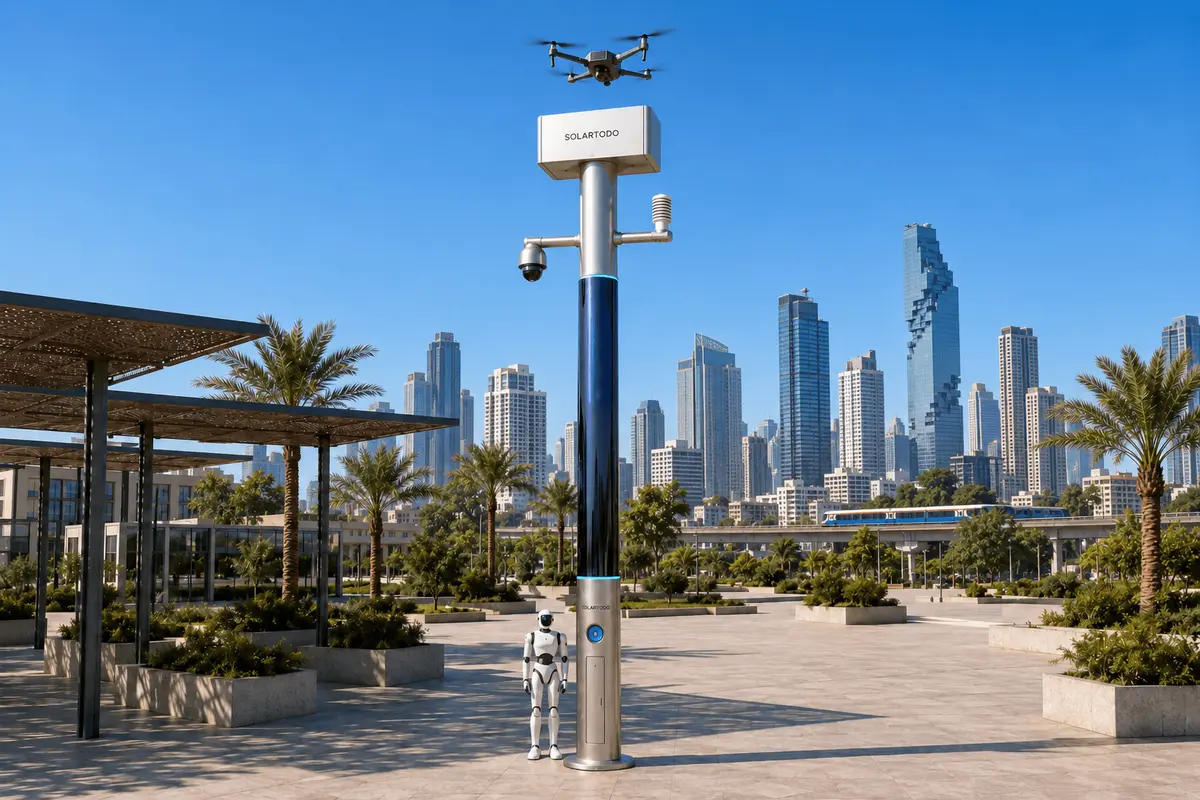
A City AI Pole is a non-lighting physical-AI edge node that combines local sensing, computing, off-grid energy storage, and drone and ground-robot operations. SOLARTODO Sentinel’s Sky Hub form runs OTATODO on-pole. This proposed Bangkok configuration supports a power utility’s post-disaster boundary surveillance, coordinating PTZ-led night assessment and authorized patrols while keeping raw video and sensor data on the pole.
1. Define the holiday security task along the river network
For a Bangkok power utility, post-disaster security begins with the boundaries around assets awaiting full restoration: a riverside compound, a canal-side service entrance, or an access path beside distribution infrastructure. This proposed case places SOLARTODO Sentinel Sky Hub nodes at selected surveillance gaps after flooding, with the holiday period acting as the planning trigger for night coverage. It describes an illustrative configuration, not a named customer installation or achieved outcome.
Bangkok’s river-network setting makes boundary planning more complex than drawing a fence on a map. Water approaches, canal paths, bridges and land entrances require different observation positions. The Bangkok Metropolitan Administration’s drainage portal documents canal mapping, water-level monitoring and pumping systems, providing relevant geographic context rather than evidence of this proposed deployment. Source: Bangkok drainage portal.
Here, border-watch means watching the utility asset perimeter and its land-water interfaces. The task is to identify an unexpected approach, distinguish ordinary movement from a potential intrusion, and authorize a proportionate response. It does not imply an international border operation.
The primary operational problem is night-response: a distant team may receive an alarm without enough context to choose its next action. The proposed plan therefore makes PTZ observation the first assessment tool and patrol frequency the principal evaluation metric. Sky Hub is the flagship pole-form deployment of Sentinel, a mature, in-service product. The Bangkok layout, duty cycle and acceptance targets remain proposed and subject to final engineering confirmation.
2. Place PTZ-led infill nodes where restoration leaves observation gaps
Begin with a joint walk-through by utility security, restoration and maintenance personnel. Identify temporary fence openings, canal-facing approaches, equipment staging areas and entrances whose usual observation arrangements were disrupted. Select node positions according to actual sightlines and safe access, rather than assuming every pole covers an identical radius. Assess foundation condition, flood exposure, maintenance access and safe drone recovery space before installation.
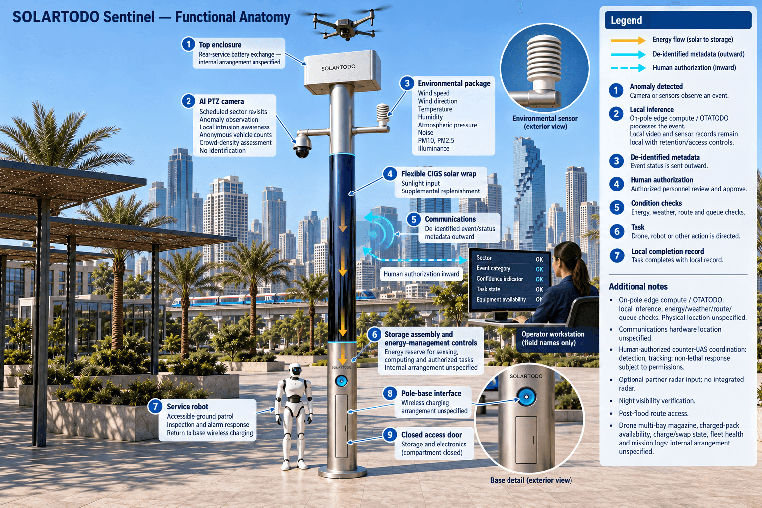
The proposed configuration centers on an AI PTZ camera. Its scheduled views revisit defined boundary sectors, while local perception supports intrusion awareness, anonymous vehicle counts and crowd-density assessment. During an event, the camera turns toward the relevant sector to support local assessment. These functions do not establish identity. Night suitability requires site checks of available scene visibility, reflections from water, vegetation, rain and camera operating limits; low-light observation must be verified under representative conditions.
Sentinel is a PURE smart pole with no lighting system. Its nine integrated capabilities combine the intelligent pole, drone operations, automated drone battery exchange, drone operations management, ground robot operations, security sensing, environmental monitoring, edge AI compute and human-authorized counter-UAS coordination. Each supports the same boundary-security task rather than creating separate monitoring silos.
The environmental package measures wind speed, wind direction, temperature, humidity, atmospheric pressure, noise, PM10, PM2.5 and illuminance. Wind and visibility-related observations inform operational decisions; illuminance records observation conditions. Neither a clear camera view nor an environmental reading alone authorizes a sortie. Maintenance teams must also confirm that the recovery location and ground route remain usable after the disaster.
3. Run one authorized night-response loop
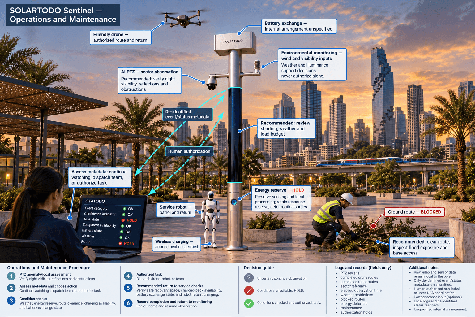
OTATODO connects sensing, authorized assessment and response, edge-compute scheduling, and field operations and maintenance through one common-operating-picture command view. For this plan, the remote utility operator receives de-identified event and status metadata: the affected sector, event category, confidence indicator, task state and equipment availability. Raw video and sensor data remain on the pole, where local inference processes them. Remote assessment must work within that information boundary.
A PTZ event first triggers additional local observation. The operator then assesses the event metadata and chooses whether to continue watching, dispatch a utility response team, or authorize a field task. The edge scheduler checks energy reserve, weather inputs, route availability and the existing task queue before releasing an approved mission. Uncertain observations remain uncertain; a confidence score is not proof of intrusion.
A friendly drone can launch, inspect a permitted boundary route, return and receive another task without an operator stationed at the pole. A multi-bay battery magazine performs an automated rear-service battery exchange after landing, providing a charged pack for relaunch. Several consecutive sorties depend on charged-pack availability, operating conditions and the approved energy budget. Drone management tracks routes, the charge/swap state machine, task queues, fleet health and mission logs.
A service robot handles accessible ground patrols, inspection and alarm response, coordinates with aerial observation, and returns to the pole base for wireless charging. For an unauthorized drone, Sentinel supports detection, tracking and command coordination. Only a human-authorized, non-lethal response may command the friendly drone to perform soft aerial net-capture or close-approach deterrence, subject to applicable permissions and operating conditions. Radar is not built into the pole; any radar contribution is an optional partner-sensor input.
4. Budget fully off-grid energy for the holiday duty cycle
The node operates fully off-grid using on-pole solar replenishment and battery storage, with no grid, city or site power. The proposed energy architecture combines approximately 15 m² of flexible CIGS thin-film wrapped through 360° around a roughly 8 m-tall, 0.6 m-wide cylindrical body, with approximately 2.4–2.7 kWp nameplate capacity and 5–20 kWh-class storage. Final usable storage depends on the selected configuration and operating limits.
Nameplate capacity must not be treated as continuous output. A vertical cylinder receives direct sunlight on its sun-facing projection, not across the entire wrap simultaneously. As a reference for a high-irradiance region such as Saudi Arabia, realistic clear-sky output is roughly 0.8–1.1 kW DC peak and about 6–9 kWh per day, with peaks tending toward mid-morning or afternoon rather than noon. These figures are not a Bangkok generation forecast.
Bangkok engineering must account for local shading, cloud, rain, orientation, temperature and conversion losses. Solar is supplemental replenishment, while storage buffers night operation and higher-power drone and robot tasks. Storage does not create energy: sustained operation requires a balanced load budget, planned replenishment and a defined maintenance response when generation remains insufficient.
Before a holiday watch period, the utility should approve a priority order: preserve essential sensing and local processing, retain response reserve, and admit routine sorties only within the remaining budget. Defer lower-priority tasks when reserves tighten. Record each energy-related deferral so the patrol-frequency evaluation reflects actual availability. This makes the operational promise a scheduled, measurable service rather than an assertion of unlimited solar self-sufficiency.
5. Evaluate patrol frequency and retain a usable operational record
Define a patrol before counting one. A PTZ sector revisit, a completed drone route and a completed robot route are separate observation activities with different scope. Keep separate counters and record a shared boundary-sector reference so the utility can see whether increased activity actually revisits the vulnerable approaches. A launch, an aborted task or repeated views of one entrance must not inflate completed-route totals.
Use completed patrols per watch window and elapsed time between valid sector observations as the primary evaluation measures. Compare a documented baseline with an agreed target under comparable watch duration and sector definitions. Record weather restrictions, blocked routes, energy deferrals, maintenance interruptions and human authorization holds alongside the counts. An increased patrol-frequency target is a planning objective, not evidence of faster response or fewer incidents.
The illustrative assumptions below let a buyer calculate watch capacity and review effort without implying product performance. The proposed evaluation should also check whether event metadata provides enough context for authorized decisions, whether local records support investigation, and whether battery exchange and robot return remain dependable under the agreed operating envelope. Any unresolved observation gap becomes an engineering or operating action.
Raw video and sensor records stay on-pole under defined retention and access controls; only de-identified event and status metadata may leave. Describe this architecture as designed for local processing and PDPL-LGPD-oriented, without asserting certification or established legal compliance. Bangkok-specific privacy and operational requirements require separate review. The acceptance decision should rest on local evidence, verified night observation and sustainable patrol scheduling, with the final configuration subject to engineering confirmation.
System Configuration
| Parameter | Configuration |
|---|---|
| Node and operating system | SOLARTODO Sentinel Sky Hub PURE non-lighting pole running OTATODO; fully off-grid |
| Security camera | AI PTZ with scheduled boundary-sector revisits and on-pole intrusion assessment; night suitability verified on site |
| Edge AI and data | On-pole inference and workload scheduling; raw video and sensor data retained locally; de-identified event/status metadata only for export |
| Solar and storage | Approximately 15 m² of 360° flexible CIGS wrap, 2.4–2.7 kWp nameplate and 5–20 kWh-class storage; final sizing subject to engineering |
| Air and ground operations | Autonomous drone return and rear-service multi-bay battery exchange; service robot return to base wireless charging |
| Environmental sensing | Wind speed/direction, temperature, humidity, atmospheric pressure, noise, PM10, PM2.5 and illuminance |
| Command and coordination | Common-operating-picture task management and human authorization; non-lethal counter-UAS coordination; no integrated radar |
How It Works
- The PTZ camera flags a boundary anomaly for on-pole processing.
- Edge AI produces de-identified event metadata while retaining raw data locally.
- A human operator assesses the metadata and authorizes a proportionate response.
- OTATODO checks energy, weather and route conditions before scheduling the authorized task.
- The drone, robot or utility team performs the assigned observation or response.
- The node records task completion locally and shares de-identified status for patrol review.
Planning Assumptions (Indicative)
Illustrative planning inputs a buyer can recompute — target metrics, not achieved results. Subject to final engineering confirmation.
| Metric | Planning assumption | Indicative value |
|---|---|---|
| Baseline patrol frequency | ILLUSTRATIVE ONLY: assume 4 completed boundary routes during an 8-hour night watch; establish the actual baseline separately. | 4 routes ÷ 8 hours = 0.5 completed routes/hour |
| Target patrol frequency | ILLUSTRATIVE ONLY: evaluate a target of 8 completed boundary routes during the same 8-hour watch; feasibility is unverified. | 8 routes ÷ 8 hours = 1 completed route/hour |
| Planned route increment | ILLUSTRATIVE ONLY: compare 8 target routes with 4 baseline routes per night across 5 holiday watch nights. | (8 − 4) × 5 = 20 additional planned routes |
| Scheduled airborne task energy | ILLUSTRATIVE ONLY: budget 4 sorties at an assumed 0.25 kWh per sortie; exclude charging losses, reserve and other node loads. | 4 × 0.25 kWh = 1 kWh of assumed sortie energy |
| Evaluation review effort | ILLUSTRATIVE ONLY: schedule 2 review sessions per week for 4 weeks, lasting 30 minutes each. | 2 × 4 × 30 minutes = 240 minutes of planned review |
Deployed Equipment
- Sentinel Sky Hub non-lighting pole body with flexible CIGS solar wrap
- Battery storage assembly with energy-management controls
- AI PTZ camera and on-pole edge-compute enclosure
- Nine-parameter environmental sensing package
- Friendly patrol drone with automated rear-service multi-bay battery magazine
- Service robot with pole-base wireless charging interface
- Communications equipment for de-identified event and status exchange
Frequently Asked Questions
Is this a verified Bangkok customer deployment?
No specific Bangkok installation or achieved result is asserted. This is a proposed operations case applying Sentinel’s mature, in-service capabilities to a power utility’s post-disaster boundary-security task. Node locations, equipment sizing, permissions and evaluation targets require site assessment and final engineering confirmation.
How does the pole support night-response without a lighting system?
The PTZ camera revisits selected boundary sectors and supports local anomaly assessment, followed by authorized drone, robot or utility-team tasks. Camera suitability must be checked against actual nighttime visibility, rain, reflections and obstructions. The pole includes no lighting system, and the proposal makes no guarantee of observation in every darkness condition.
Can solar support continuous drone and robot activity?
Continuous high-power activity is not assumed. Solar replenishes a fully off-grid battery-backed node, while storage buffers scheduled tasks. Bangkok generation and total load require engineering assessment. Patrol frequency must remain within the available energy budget, with response reserves, task deferrals and maintenance arrangements explicitly defined.
What can the remote utility operator see?
The remote command view may receive de-identified event and status metadata, including sector references, task progress and equipment availability. Raw video and sensor data stay on the pole for local processing. Local access controls and retention arrangements must support authorized review without introducing raw-data export.
What does border-watch mean in this Bangkok plan?
It means surveillance of utility asset boundaries where land entrances, canal paths and water-facing approaches meet. The proposed workflow checks unexpected movement, supports authorized assessment and coordinates field observation. It does not describe international border enforcement, and it does not identify people through face or licence-plate recognition.
How should the buyer judge operational value?
Start with consistently defined completed patrols per watch window and time between valid sector observations. Keep PTZ revisits, drone routes and robot routes separate. Compare targets with a documented baseline, retaining weather, energy and authorization interruptions so activity counts do not conceal observation gaps or imply unverified security outcomes.
Explore Further
- City AI Pole / smart streetlight product line
- More smart-city deployment cases
- Talk to our engineering team
Planning a similar physical-AI deployment for streets, campuses or public spaces? Request an engineering consultation